You are here: Home > Network List > UW - Pacific Northwest Regional Seismic Network Stations List
> Station GNW Green Mountain (BB) > Earthquake Result Viewer
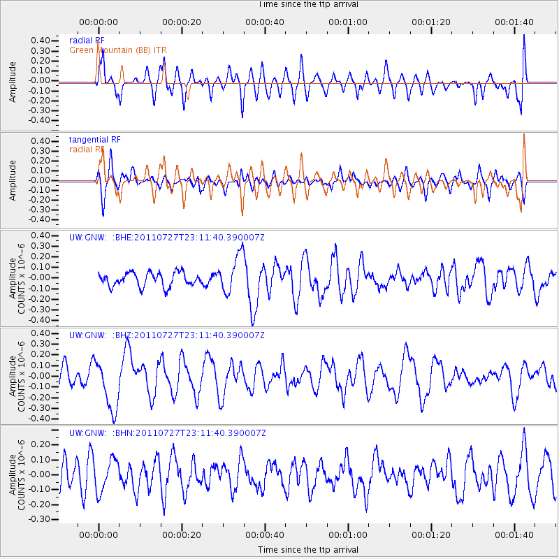
GNW Green Mountain (BB) - Earthquake Result Viewer
*The percent match for this event was below the threshold and hence no stack was calculated.
| Earthquake location: |
Northern Mid-Atlantic Ridge |
| Earthquake latitude/longitude: |
10.8/-43.4 |
| Earthquake time(UTC): |
2011/07/27 (208) 23:00:30 GMT |
| Earthquake Depth: |
10 km |
| Earthquake Magnitude: |
5.6 MB, 5.6 MS, 6.0 MW, 5.9 MW |
| Earthquake Catalog/Contributor: |
WHDF/NEIC |
|
| Network: |
UW Pacific Northwest Regional Seismic Network |
| Station: |
GNW Green Mountain (BB) |
| Lat/Lon: |
47.56 N/122.83 W |
| Elevation: |
160 m |
|
| Distance: |
75.0 deg |
| Az: |
316.428 deg |
| Baz: |
90.385 deg |
| Ray Param: |
$rayparam |
*The percent match for this event was below the threshold and hence was not used in the summary stack. |
|
| Radial Match: |
63.621826 % |
| Radial Bump: |
400 |
| Transverse Match: |
60.87693 % |
| Transverse Bump: |
400 |
| SOD ConfigId: |
405110 |
| Insert Time: |
2011-12-29 09:30:01.995 +0000 |
| GWidth: |
2.5 |
| Max Bumps: |
400 |
| Tol: |
0.001 |
|
Signal To Noise
| Channel | StoN | STA | LTA |
| UW:GNW: :BHZ:20110727T23:11:40.390007Z | 3.3773572 | 2.3976006E-7 | 7.099043E-8 |
| UW:GNW: :BHN:20110727T23:11:40.390007Z | 1.3230218 | 1.08900934E-7 | 8.2312276E-8 |
| UW:GNW: :BHE:20110727T23:11:40.390007Z | 2.8804336 | 1.8332423E-7 | 6.364467E-8 |
| Arrivals |
| Ps | |
| PpPs | |
| PsPs/PpSs | |


