You are here: Home > Network List > UW - Pacific Northwest Regional Seismic Network Stations List
> Station LEBA Lebam, WA, USA > Earthquake Result Viewer
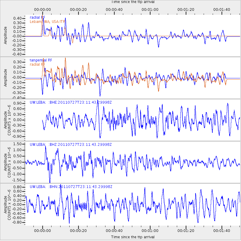
LEBA Lebam, WA, USA - Earthquake Result Viewer
*The percent match for this event was below the threshold and hence no stack was calculated.
| Earthquake location: |
Northern Mid-Atlantic Ridge |
| Earthquake latitude/longitude: |
10.8/-43.4 |
| Earthquake time(UTC): |
2011/07/27 (208) 23:00:30 GMT |
| Earthquake Depth: |
10 km |
| Earthquake Magnitude: |
5.6 MB, 5.6 MS, 6.0 MW, 5.9 MW |
| Earthquake Catalog/Contributor: |
WHDF/NEIC |
|
| Network: |
UW Pacific Northwest Regional Seismic Network |
| Station: |
LEBA Lebam, WA, USA |
| Lat/Lon: |
46.55 N/123.56 W |
| Elevation: |
73 m |
|
| Distance: |
75.5 deg |
| Az: |
315.375 deg |
| Baz: |
89.578 deg |
| Ray Param: |
$rayparam |
*The percent match for this event was below the threshold and hence was not used in the summary stack. |
|
| Radial Match: |
60.04756 % |
| Radial Bump: |
400 |
| Transverse Match: |
63.793324 % |
| Transverse Bump: |
400 |
| SOD ConfigId: |
405110 |
| Insert Time: |
2011-12-29 09:30:54.705 +0000 |
| GWidth: |
2.5 |
| Max Bumps: |
400 |
| Tol: |
0.001 |
|
Signal To Noise
| Channel | StoN | STA | LTA |
| UW:LEBA: :BHZ:20110727T23:11:43.29998Z | 5.3826985 | 6.747338E-7 | 1.2535233E-7 |
| UW:LEBA: :BHN:20110727T23:11:43.29998Z | 0.9021538 | 1.5786715E-7 | 1.7498918E-7 |
| UW:LEBA: :BHE:20110727T23:11:43.29998Z | 2.4848902 | 5.9380324E-7 | 2.3896558E-7 |
| Arrivals |
| Ps | |
| PpPs | |
| PsPs/PpSs | |


