You are here: Home > Network List > AK - Alaska Regional Network Stations List
> Station GAMB Gambell Broadband > Earthquake Result Viewer
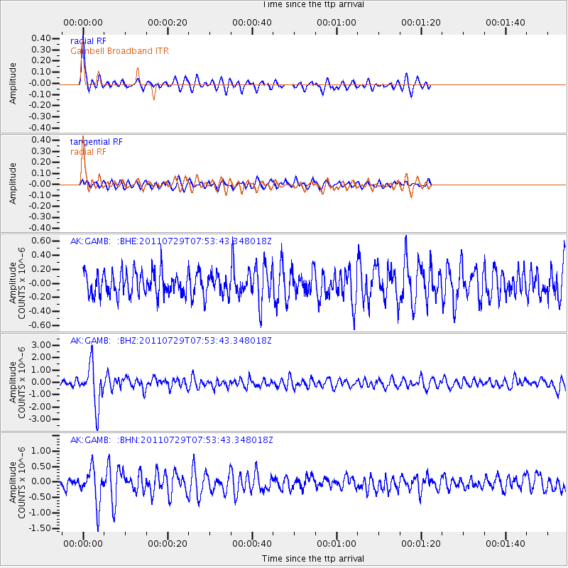
GAMB Gambell Broadband - Earthquake Result Viewer
*The percent match for this event was below the threshold and hence no stack was calculated.
| Earthquake location: |
South Of Fiji Islands |
| Earthquake latitude/longitude: |
-23.8/179.8 |
| Earthquake time(UTC): |
2011/07/29 (210) 07:42:22 GMT |
| Earthquake Depth: |
523 km |
| Earthquake Magnitude: |
6.2 MB, 6.7 MW, 6.7 MW |
| Earthquake Catalog/Contributor: |
WHDF/NEIC |
|
| Network: |
AK Alaska Regional Network |
| Station: |
GAMB Gambell Broadband |
| Lat/Lon: |
63.78 N/171.70 W |
| Elevation: |
10 m |
|
| Distance: |
87.5 deg |
| Az: |
3.786 deg |
| Baz: |
187.825 deg |
| Ray Param: |
$rayparam |
*The percent match for this event was below the threshold and hence was not used in the summary stack. |
|
| Radial Match: |
70.56365 % |
| Radial Bump: |
400 |
| Transverse Match: |
48.471317 % |
| Transverse Bump: |
400 |
| SOD ConfigId: |
405110 |
| Insert Time: |
2011-12-29 09:43:50.009 +0000 |
| GWidth: |
2.5 |
| Max Bumps: |
400 |
| Tol: |
0.001 |
|
Signal To Noise
| Channel | StoN | STA | LTA |
| AK:GAMB: :BHZ:20110729T07:53:43.348018Z | 8.64056 | 1.6873165E-6 | 1.9527862E-7 |
| AK:GAMB: :BHN:20110729T07:53:43.348018Z | 3.8909142 | 5.7111083E-7 | 1.4678062E-7 |
| AK:GAMB: :BHE:20110729T07:53:43.348018Z | 0.92927355 | 1.4769908E-7 | 1.5894037E-7 |
| Arrivals |
| Ps | |
| PpPs | |
| PsPs/PpSs | |


