You are here: Home > Network List > TA - USArray Transportable Network (new EarthScope stations) Stations List
> Station P49A Miami Univ. Ecology Research Center, OH, USA > Earthquake Result Viewer
P49A Miami Univ. Ecology Research Center, OH, USA - Earthquake Result Viewer
| Earthquake location: |
Near Coast Of Northern Chile |
| Earthquake latitude/longitude: |
-20.0/-70.6 |
| Earthquake time(UTC): |
2014/04/02 (092) 00:37:49 GMT |
| Earthquake Depth: |
20 km |
| Earthquake Magnitude: |
5.4 mb |
| Earthquake Catalog/Contributor: |
ISC/ISC |
|
| Network: |
TA USArray Transportable Network (new EarthScope stations) |
| Station: |
P49A Miami Univ. Ecology Research Center, OH, USA |
| Lat/Lon: |
39.53 N/84.72 W |
| Elevation: |
272 m |
|
| Distance: |
60.7 deg |
| Az: |
347.52 deg |
| Baz: |
164.763 deg |
| Ray Param: |
0.06136473 |
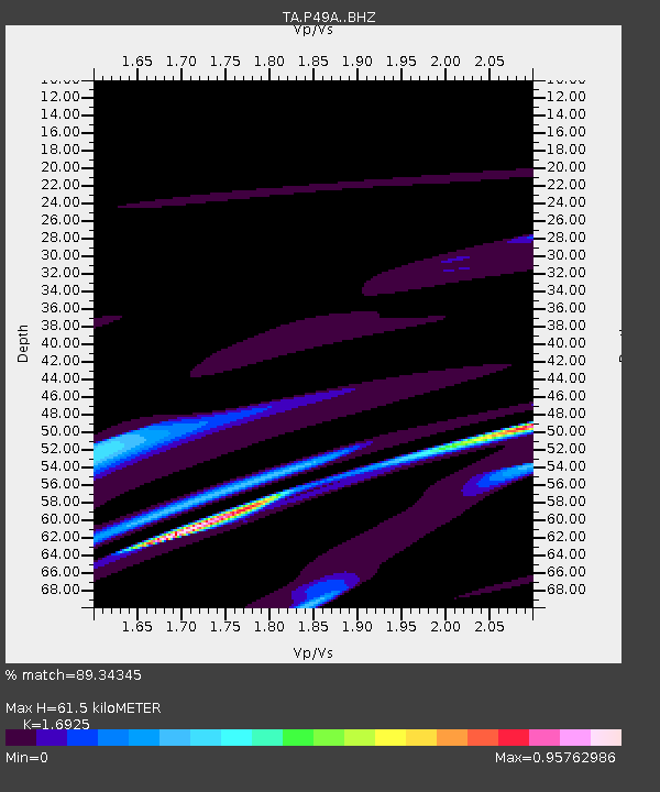
| Estimated Moho Depth: |
61.5 km |
| Estimated Crust Vp/Vs: |
1.69 |
| Assumed Crust Vp: |
6.498 km/s |
| Estimated Crust Vs: |
3.839 km/s |
| Estimated Crust Poisson's Ratio: |
0.23 |
|
| Radial Match: |
89.34345 % |
| Radial Bump: |
400 |
| Transverse Match: |
52.447765 % |
| Transverse Bump: |
315 |
| SOD ConfigId: |
3390531 |
| Insert Time: |
2019-04-11 00:38:39.321 +0000 |
| GWidth: |
2.5 |
| Max Bumps: |
400 |
| Tol: |
0.001 |
|

Signal To Noise
| Channel | StoN | STA | LTA |
| TA:P49A: :BHZ:20140402T00:47:27.650029Z | 1.5924747 | 2.283695E-5 | 1.4340542E-5 |
| TA:P49A: :BHN:20140402T00:47:27.650029Z | 1.5054452 | 2.0313819E-5 | 1.3493562E-5 |
| TA:P49A: :BHE:20140402T00:47:27.650029Z | 0.8516277 | 6.2445865E-6 | 7.332531E-6 |
| Arrivals |
| Ps | 6.9 SECOND |
| PpPs | 24 SECOND |
| PsPs/PpSs | 31 SECOND |


