You are here: Home > Network List > TA - USArray Transportable Network (new EarthScope stations) Stations List
> Station T56A Rocky Mt, VA, USA > Earthquake Result Viewer
T56A Rocky Mt, VA, USA - Earthquake Result Viewer
| Earthquake location: |
Near Coast Of Northern Chile |
| Earthquake latitude/longitude: |
-20.0/-70.6 |
| Earthquake time(UTC): |
2014/04/02 (092) 00:37:49 GMT |
| Earthquake Depth: |
20 km |
| Earthquake Magnitude: |
5.4 mb |
| Earthquake Catalog/Contributor: |
ISC/ISC |
|
| Network: |
TA USArray Transportable Network (new EarthScope stations) |
| Station: |
T56A Rocky Mt, VA, USA |
| Lat/Lon: |
37.03 N/80.03 W |
| Elevation: |
387 m |
|
| Distance: |
57.4 deg |
| Az: |
351.062 deg |
| Baz: |
169.479 deg |
| Ray Param: |
0.06349379 |
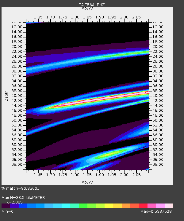
| Estimated Moho Depth: |
38.5 km |
| Estimated Crust Vp/Vs: |
2.09 |
| Assumed Crust Vp: |
6.159 km/s |
| Estimated Crust Vs: |
2.954 km/s |
| Estimated Crust Poisson's Ratio: |
0.35 |
|
| Radial Match: |
90.35601 % |
| Radial Bump: |
303 |
| Transverse Match: |
65.66224 % |
| Transverse Bump: |
400 |
| SOD ConfigId: |
3390531 |
| Insert Time: |
2019-04-11 00:38:49.882 +0000 |
| GWidth: |
2.5 |
| Max Bumps: |
400 |
| Tol: |
0.001 |
|
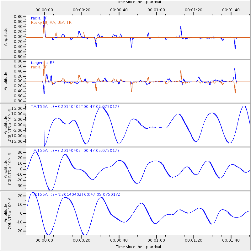
Signal To Noise
| Channel | StoN | STA | LTA |
| TA:T56A: :BHZ:20140402T00:47:05.075017Z | 1.9002094 | 3.0370917E-5 | 1.598293E-5 |
| TA:T56A: :BHN:20140402T00:47:05.075017Z | 1.7202276 | 2.1021084E-5 | 1.2219943E-5 |
| TA:T56A: :BHE:20140402T00:47:05.075017Z | 2.0921412 | 1.70297E-5 | 8.139843E-6 |
| Arrivals |
| Ps | 7.0 SECOND |
| PpPs | 19 SECOND |
| PsPs/PpSs | 26 SECOND |


