You are here: Home > Network List > BK - Berkeley Digital Seismograph Network Stations List
> Station SAO San Andreas Geophysical Obs., Hollister, CA, USA > Earthquake Result Viewer
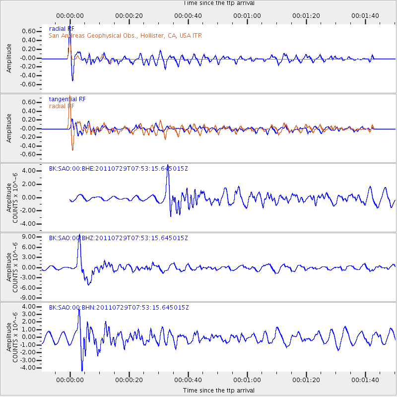
SAO San Andreas Geophysical Obs., Hollister, CA, USA - Earthquake Result Viewer
*The percent match for this event was below the threshold and hence no stack was calculated.
| Earthquake location: |
South Of Fiji Islands |
| Earthquake latitude/longitude: |
-23.8/179.8 |
| Earthquake time(UTC): |
2011/07/29 (210) 07:42:22 GMT |
| Earthquake Depth: |
523 km |
| Earthquake Magnitude: |
6.2 MB, 6.7 MW, 6.7 MW |
| Earthquake Catalog/Contributor: |
WHDF/NEIC |
|
| Network: |
BK Berkeley Digital Seismograph Network |
| Station: |
SAO San Andreas Geophysical Obs., Hollister, CA, USA |
| Lat/Lon: |
36.76 N/121.45 W |
| Elevation: |
317 m |
|
| Distance: |
81.8 deg |
| Az: |
43.938 deg |
| Baz: |
232.331 deg |
| Ray Param: |
$rayparam |
*The percent match for this event was below the threshold and hence was not used in the summary stack. |
|
| Radial Match: |
77.400604 % |
| Radial Bump: |
400 |
| Transverse Match: |
64.80433 % |
| Transverse Bump: |
400 |
| SOD ConfigId: |
405110 |
| Insert Time: |
2011-12-29 09:51:16.946 +0000 |
| GWidth: |
2.5 |
| Max Bumps: |
400 |
| Tol: |
0.001 |
|
Signal To Noise
| Channel | StoN | STA | LTA |
| BK:SAO:00:BHZ:20110729T07:53:15.645015Z | 12.3935995 | 3.535005E-6 | 2.8522825E-7 |
| BK:SAO:00:BHN:20110729T07:53:15.645015Z | 3.2892096 | 1.8161479E-6 | 5.521533E-7 |
| BK:SAO:00:BHE:20110729T07:53:15.645015Z | 6.7983937 | 1.8700764E-6 | 2.7507622E-7 |
| Arrivals |
| Ps | |
| PpPs | |
| PsPs/PpSs | |


