You are here: Home > Network List > WY - Yellowstone Wyoming Seismic Network Stations List
> Station YTP The Promontory, YNP, WY, USA > Earthquake Result Viewer
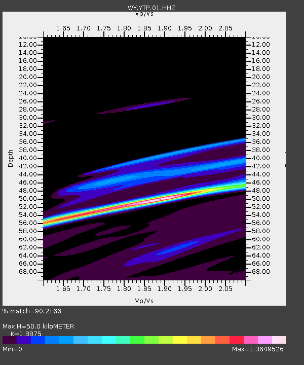
YTP The Promontory, YNP, WY, USA - Earthquake Result Viewer
| Earthquake location: |
Near Coast Of Northern Chile |
| Earthquake latitude/longitude: |
-20.0/-70.6 |
| Earthquake time(UTC): |
2014/04/02 (092) 00:37:49 GMT |
| Earthquake Depth: |
20 km |
| Earthquake Magnitude: |
5.4 mb |
| Earthquake Catalog/Contributor: |
ISC/ISC |
|
| Network: |
WY Yellowstone Wyoming Seismic Network |
| Station: |
YTP The Promontory, YNP, WY, USA |
| Lat/Lon: |
44.39 N/110.29 W |
| Elevation: |
2384 m |
|
| Distance: |
73.6 deg |
| Az: |
331.51 deg |
| Baz: |
141.26 deg |
| Ray Param: |
0.05287031 |
| Estimated Moho Depth: |
50.0 km |
| Estimated Crust Vp/Vs: |
1.89 |
| Assumed Crust Vp: |
6.35 km/s |
| Estimated Crust Vs: |
3.364 km/s |
| Estimated Crust Poisson's Ratio: |
0.30 |
|
| Radial Match: |
90.2166 % |
| Radial Bump: |
400 |
| Transverse Match: |
70.788734 % |
| Transverse Bump: |
400 |
| SOD ConfigId: |
3390531 |
| Insert Time: |
2019-04-11 00:39:59.998 +0000 |
| GWidth: |
2.5 |
| Max Bumps: |
400 |
| Tol: |
0.001 |
|

Signal To Noise
| Channel | StoN | STA | LTA |
| WY:YTP:01:HHZ:20140402T00:48:49.638005Z | 0.75983346 | 6.731774E-7 | 8.859539E-7 |
| WY:YTP:01:HHN:20140402T00:48:49.638005Z | 2.4797049 | 1.0351513E-6 | 4.1744937E-7 |
| WY:YTP:01:HHE:20140402T00:48:49.638005Z | 0.7804508 | 5.747652E-7 | 7.3645276E-7 |
| Arrivals |
| Ps | 7.2 SECOND |
| PpPs | 22 SECOND |
| PsPs/PpSs | 29 SECOND |


