You are here: Home > Network List > CI - Caltech Regional Seismic Network Stations List
> Station SWS Sam W. Stewart, Westmorland, CA, USA > Earthquake Result Viewer
SWS Sam W. Stewart, Westmorland, CA, USA - Earthquake Result Viewer

| Earthquake location: |
South Of Fiji Islands |
| Earthquake latitude/longitude: |
-23.8/179.8 |
| Earthquake time(UTC): |
2011/07/29 (210) 07:42:22 GMT |
| Earthquake Depth: |
523 km |
| Earthquake Magnitude: |
6.2 MB, 6.7 MW, 6.7 MW |
| Earthquake Catalog/Contributor: |
WHDF/NEIC |
|
| Network: |
CI Caltech Regional Seismic Network |
| Station: |
SWS Sam W. Stewart, Westmorland, CA, USA |
| Lat/Lon: |
32.94 N/115.80 W |
| Elevation: |
140 m |
|
| Distance: |
83.4 deg |
| Az: |
49.793 deg |
| Baz: |
236.304 deg |
| Ray Param: |
0.044720255 |
| Estimated Moho Depth: |
40.5 km |
| Estimated Crust Vp/Vs: |
2.06 |
| Assumed Crust Vp: |
6.155 km/s |
| Estimated Crust Vs: |
2.995 km/s |
| Estimated Crust Poisson's Ratio: |
0.34 |
|
| Radial Match: |
88.76344 % |
| Radial Bump: |
400 |
| Transverse Match: |
85.89019 % |
| Transverse Bump: |
400 |
| SOD ConfigId: |
405110 |
| Insert Time: |
2011-12-29 09:54:53.503 +0000 |
| GWidth: |
2.5 |
| Max Bumps: |
400 |
| Tol: |
0.001 |
|
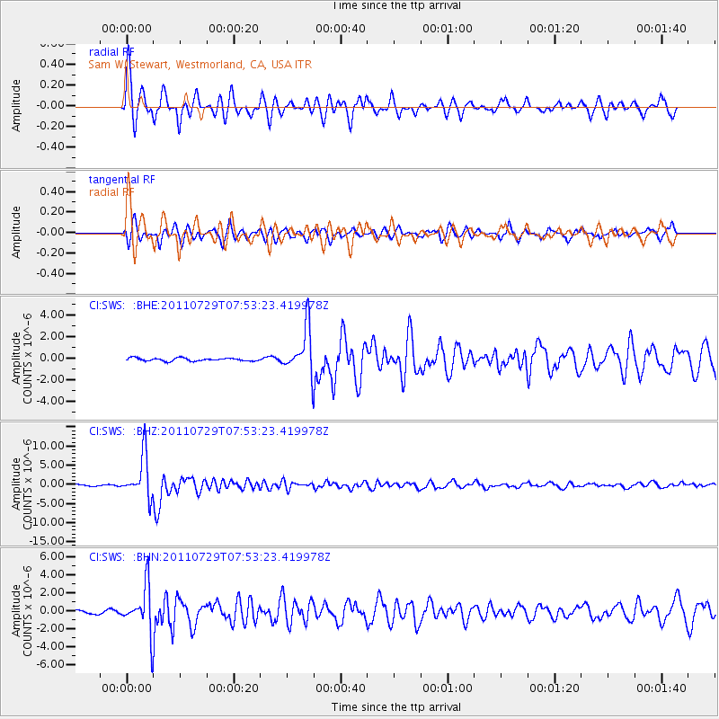
Signal To Noise
| Channel | StoN | STA | LTA |
| CI:SWS: :BHZ:20110729T07:53:23.419978Z | 37.73133 | 5.695044E-6 | 1.5093673E-7 |
| CI:SWS: :BHN:20110729T07:53:23.419978Z | 21.256042 | 2.6058315E-6 | 1.2259251E-7 |
| CI:SWS: :BHE:20110729T07:53:23.419978Z | 15.809515 | 2.1689323E-6 | 1.3719158E-7 |
| Arrivals |
| Ps | 7.1 SECOND |
| PpPs | 20 SECOND |
| PsPs/PpSs | 27 SECOND |


