You are here: Home > Network List > CI - Caltech Regional Seismic Network Stations List
> Station SMM Simmler, CA, USA > Earthquake Result Viewer
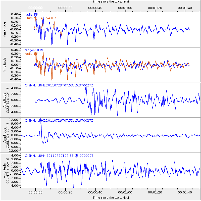
SMM Simmler, CA, USA - Earthquake Result Viewer
*The percent match for this event was below the threshold and hence no stack was calculated.
| Earthquake location: |
South Of Fiji Islands |
| Earthquake latitude/longitude: |
-23.8/179.8 |
| Earthquake time(UTC): |
2011/07/29 (210) 07:42:22 GMT |
| Earthquake Depth: |
523 km |
| Earthquake Magnitude: |
6.2 MB, 6.7 MW, 6.7 MW |
| Earthquake Catalog/Contributor: |
WHDF/NEIC |
|
| Network: |
CI Caltech Regional Seismic Network |
| Station: |
SMM Simmler, CA, USA |
| Lat/Lon: |
35.31 N/120.00 W |
| Elevation: |
599 m |
|
| Distance: |
81.9 deg |
| Az: |
45.82 deg |
| Baz: |
233.448 deg |
| Ray Param: |
$rayparam |
*The percent match for this event was below the threshold and hence was not used in the summary stack. |
|
| Radial Match: |
79.89549 % |
| Radial Bump: |
400 |
| Transverse Match: |
64.9999 % |
| Transverse Bump: |
400 |
| SOD ConfigId: |
405110 |
| Insert Time: |
2011-12-29 09:56:23.801 +0000 |
| GWidth: |
2.5 |
| Max Bumps: |
400 |
| Tol: |
0.001 |
|
Signal To Noise
| Channel | StoN | STA | LTA |
| CI:SMM: :BHZ:20110729T07:53:15.970027Z | 21.800678 | 4.686678E-6 | 2.1497854E-7 |
| CI:SMM: :BHN:20110729T07:53:15.970027Z | 1.2029936 | 8.5637276E-7 | 7.118681E-7 |
| CI:SMM: :BHE:20110729T07:53:15.970027Z | 3.7184734 | 1.8125515E-6 | 4.8744505E-7 |
| Arrivals |
| Ps | |
| PpPs | |
| PsPs/PpSs | |


