You are here: Home > Network List > CI - Caltech Regional Seismic Network Stations List
> Station MPP McPhearson Peak > Earthquake Result Viewer
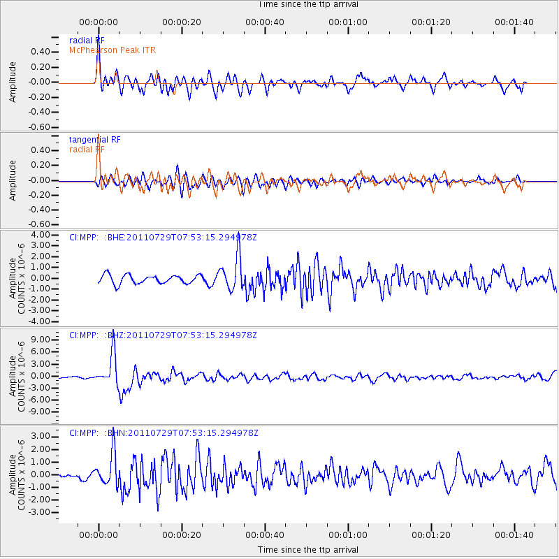
MPP McPhearson Peak - Earthquake Result Viewer
*The percent match for this event was below the threshold and hence no stack was calculated.
| Earthquake location: |
South Of Fiji Islands |
| Earthquake latitude/longitude: |
-23.8/179.8 |
| Earthquake time(UTC): |
2011/07/29 (210) 07:42:22 GMT |
| Earthquake Depth: |
523 km |
| Earthquake Magnitude: |
6.2 MB, 6.7 MW, 6.7 MW |
| Earthquake Catalog/Contributor: |
WHDF/NEIC |
|
| Network: |
CI Caltech Regional Seismic Network |
| Station: |
MPP McPhearson Peak |
| Lat/Lon: |
34.89 N/119.81 W |
| Elevation: |
1739 m |
|
| Distance: |
81.8 deg |
| Az: |
46.255 deg |
| Baz: |
233.614 deg |
| Ray Param: |
$rayparam |
*The percent match for this event was below the threshold and hence was not used in the summary stack. |
|
| Radial Match: |
73.07525 % |
| Radial Bump: |
400 |
| Transverse Match: |
65.448204 % |
| Transverse Bump: |
400 |
| SOD ConfigId: |
405110 |
| Insert Time: |
2011-12-29 09:57:07.172 +0000 |
| GWidth: |
2.5 |
| Max Bumps: |
400 |
| Tol: |
0.001 |
|
Signal To Noise
| Channel | StoN | STA | LTA |
| CI:MPP: :BHZ:20110729T07:53:15.294978Z | 17.61947 | 4.1706517E-6 | 2.36707E-7 |
| CI:MPP: :BHN:20110729T07:53:15.294978Z | 2.8277805 | 1.332636E-6 | 4.712657E-7 |
| CI:MPP: :BHE:20110729T07:53:15.294978Z | 4.082878 | 1.6256552E-6 | 3.98164E-7 |
| Arrivals |
| Ps | |
| PpPs | |
| PsPs/PpSs | |


