You are here: Home > Network List > CI - Caltech Regional Seismic Network Stations List
> Station RRX Rimrock Road, Barstow, CA, USA > Earthquake Result Viewer
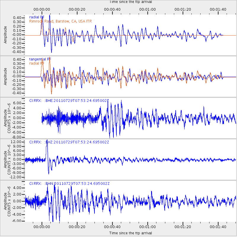
RRX Rimrock Road, Barstow, CA, USA - Earthquake Result Viewer
| Earthquake location: |
South Of Fiji Islands |
| Earthquake latitude/longitude: |
-23.8/179.8 |
| Earthquake time(UTC): |
2011/07/29 (210) 07:42:22 GMT |
| Earthquake Depth: |
523 km |
| Earthquake Magnitude: |
6.2 MB, 6.7 MW, 6.7 MW |
| Earthquake Catalog/Contributor: |
WHDF/NEIC |
|
| Network: |
CI Caltech Regional Seismic Network |
| Station: |
RRX Rimrock Road, Barstow, CA, USA |
| Lat/Lon: |
34.88 N/117.00 W |
| Elevation: |
439 m |
|
| Distance: |
83.6 deg |
| Az: |
47.621 deg |
| Baz: |
235.391 deg |
| Ray Param: |
0.044543486 |
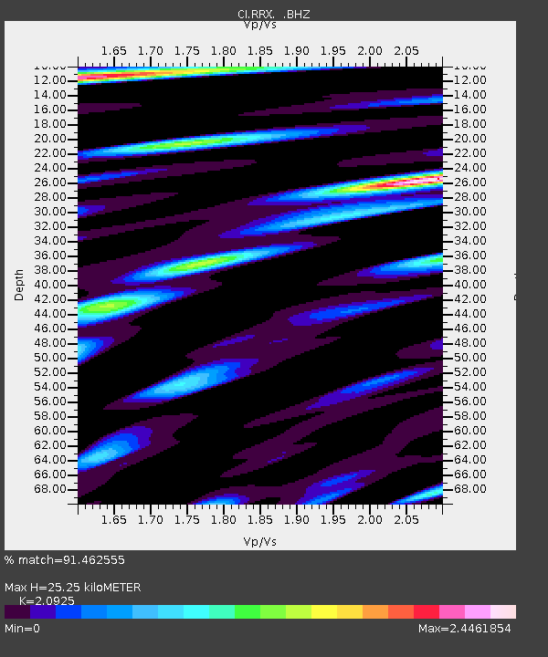
| Estimated Moho Depth: |
25.25 km |
| Estimated Crust Vp/Vs: |
2.09 |
| Assumed Crust Vp: |
6.276 km/s |
| Estimated Crust Vs: |
2.999 km/s |
| Estimated Crust Poisson's Ratio: |
0.35 |
|
| Radial Match: |
91.462555 % |
| Radial Bump: |
400 |
| Transverse Match: |
89.317055 % |
| Transverse Bump: |
400 |
| SOD ConfigId: |
405110 |
| Insert Time: |
2011-12-29 09:57:11.638 +0000 |
| GWidth: |
2.5 |
| Max Bumps: |
400 |
| Tol: |
0.001 |
|
Signal To Noise
| Channel | StoN | STA | LTA |
| CI:RRX: :BHZ:20110729T07:53:24.695002Z | 5.6382365 | 5.1893703E-6 | 9.2038897E-7 |
| CI:RRX: :BHN:20110729T07:53:24.695002Z | 1.7412726 | 1.7399971E-6 | 9.992675E-7 |
| CI:RRX: :BHE:20110729T07:53:24.695002Z | 1.295968 | 1.9550396E-6 | 1.5085553E-6 |
| Arrivals |
| Ps | 4.5 SECOND |
| PpPs | 12 SECOND |
| PsPs/PpSs | 17 SECOND |


