You are here: Home > Network List > LB - Leo Brady Network Stations List
> Station DAC Darwin, Inyo County, California, USA > Earthquake Result Viewer
DAC Darwin, Inyo County, California, USA - Earthquake Result Viewer
| Earthquake location: |
South Of Fiji Islands |
| Earthquake latitude/longitude: |
-23.8/179.8 |
| Earthquake time(UTC): |
2011/07/29 (210) 07:42:22 GMT |
| Earthquake Depth: |
523 km |
| Earthquake Magnitude: |
6.2 MB, 6.7 MW, 6.7 MW |
| Earthquake Catalog/Contributor: |
WHDF/NEIC |
|
| Network: |
LB Leo Brady Network |
| Station: |
DAC Darwin, Inyo County, California, USA |
| Lat/Lon: |
36.28 N/117.59 W |
| Elevation: |
1813 m |
|
| Distance: |
84.0 deg |
| Az: |
46.187 deg |
| Baz: |
234.891 deg |
| Ray Param: |
0.044270117 |
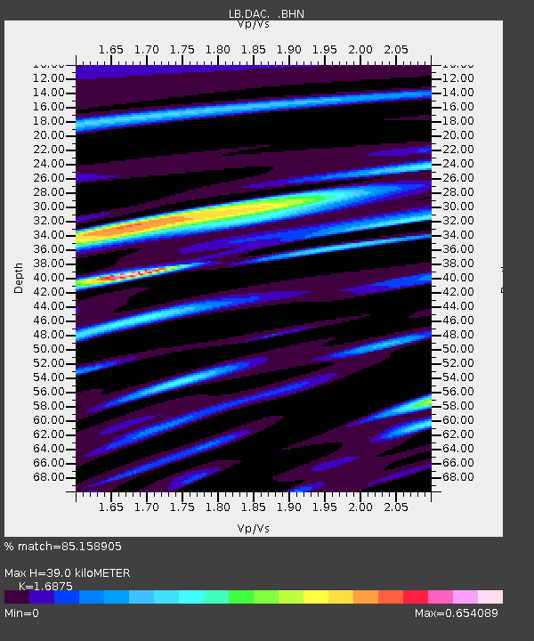
| Estimated Moho Depth: |
39.0 km |
| Estimated Crust Vp/Vs: |
1.69 |
| Assumed Crust Vp: |
6.279 km/s |
| Estimated Crust Vs: |
3.721 km/s |
| Estimated Crust Poisson's Ratio: |
0.23 |
|
| Radial Match: |
85.158905 % |
| Radial Bump: |
400 |
| Transverse Match: |
79.68172 % |
| Transverse Bump: |
400 |
| SOD ConfigId: |
405110 |
| Insert Time: |
2011-12-29 10:03:39.830 +0000 |
| GWidth: |
2.5 |
| Max Bumps: |
400 |
| Tol: |
0.001 |
|

Signal To Noise
| Channel | StoN | STA | LTA |
| LB:DAC: :BHZ:20110729T07:53:26.68603Z | 29.191229 | 3.1320099E-6 | 1.0729284E-7 |
| LB:DAC: :BHN:20110729T07:53:26.68603Z | 5.2970757 | 4.572087E-7 | 8.631341E-8 |
| LB:DAC: :BHE:20110729T07:53:26.68603Z | 9.559239 | 6.5929953E-7 | 6.896987E-8 |
| Arrivals |
| Ps | 4.4 SECOND |
| PpPs | 16 SECOND |
| PsPs/PpSs | 21 SECOND |


