You are here: Home > Network List > TA - USArray Transportable Network (new EarthScope stations) Stations List
> Station G03D McMinnville, OR, USA > Earthquake Result Viewer
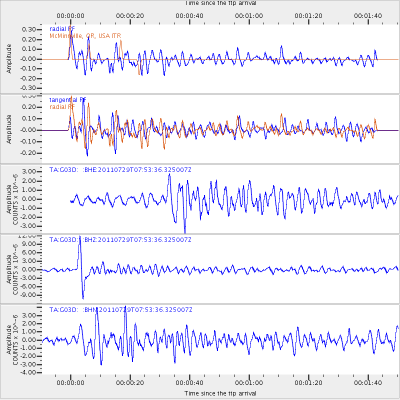
G03D McMinnville, OR, USA - Earthquake Result Viewer
*The percent match for this event was below the threshold and hence no stack was calculated.
| Earthquake location: |
South Of Fiji Islands |
| Earthquake latitude/longitude: |
-23.8/179.8 |
| Earthquake time(UTC): |
2011/07/29 (210) 07:42:22 GMT |
| Earthquake Depth: |
523 km |
| Earthquake Magnitude: |
6.2 MB, 6.7 MW, 6.7 MW |
| Earthquake Catalog/Contributor: |
WHDF/NEIC |
|
| Network: |
TA USArray Transportable Network (new EarthScope stations) |
| Station: |
G03D McMinnville, OR, USA |
| Lat/Lon: |
45.21 N/123.26 W |
| Elevation: |
222 m |
|
| Distance: |
86.0 deg |
| Az: |
36.448 deg |
| Baz: |
230.346 deg |
| Ray Param: |
$rayparam |
*The percent match for this event was below the threshold and hence was not used in the summary stack. |
|
| Radial Match: |
72.86542 % |
| Radial Bump: |
400 |
| Transverse Match: |
66.23275 % |
| Transverse Bump: |
400 |
| SOD ConfigId: |
405110 |
| Insert Time: |
2011-12-29 10:07:20.771 +0000 |
| GWidth: |
2.5 |
| Max Bumps: |
400 |
| Tol: |
0.001 |
|
Signal To Noise
| Channel | StoN | STA | LTA |
| TA:G03D: :BHZ:20110729T07:53:36.325007Z | 14.883369 | 5.1089496E-6 | 3.4326564E-7 |
| TA:G03D: :BHN:20110729T07:53:36.325007Z | 2.0875547 | 8.6272576E-7 | 4.1327098E-7 |
| TA:G03D: :BHE:20110729T07:53:36.325007Z | 3.4277806 | 1.1688766E-6 | 3.4100097E-7 |
| Arrivals |
| Ps | |
| PpPs | |
| PsPs/PpSs | |


