You are here: Home > Network List > TA - USArray Transportable Network (new EarthScope stations) Stations List
> Station I03D Drain, OR, USA > Earthquake Result Viewer
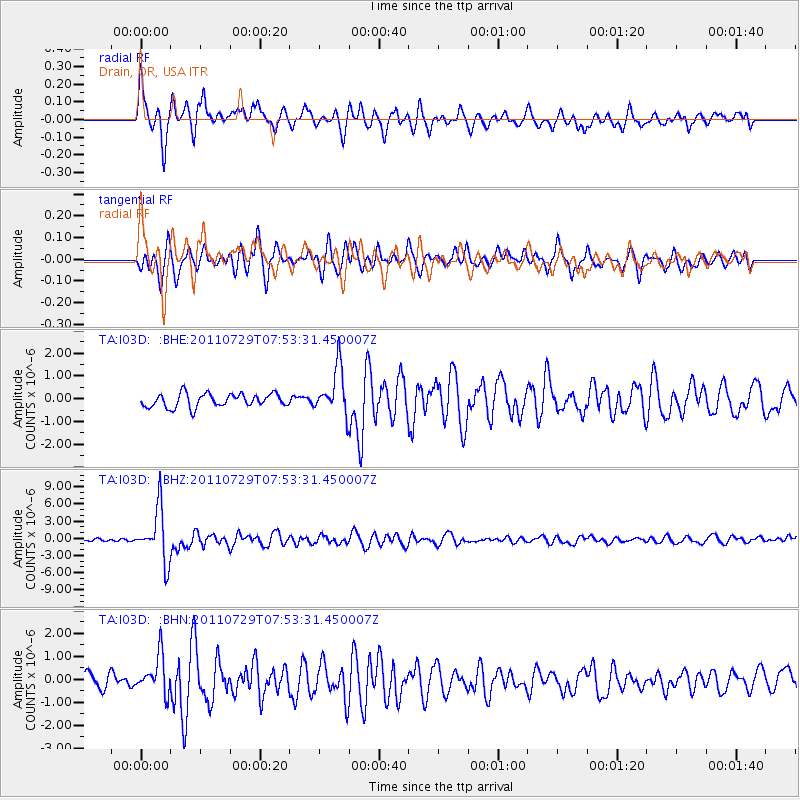
I03D Drain, OR, USA - Earthquake Result Viewer
*The percent match for this event was below the threshold and hence no stack was calculated.
| Earthquake location: |
South Of Fiji Islands |
| Earthquake latitude/longitude: |
-23.8/179.8 |
| Earthquake time(UTC): |
2011/07/29 (210) 07:42:22 GMT |
| Earthquake Depth: |
523 km |
| Earthquake Magnitude: |
6.2 MB, 6.7 MW, 6.7 MW |
| Earthquake Catalog/Contributor: |
WHDF/NEIC |
|
| Network: |
TA USArray Transportable Network (new EarthScope stations) |
| Station: |
I03D Drain, OR, USA |
| Lat/Lon: |
43.70 N/123.35 W |
| Elevation: |
140 m |
|
| Distance: |
85.0 deg |
| Az: |
37.579 deg |
| Baz: |
230.376 deg |
| Ray Param: |
$rayparam |
*The percent match for this event was below the threshold and hence was not used in the summary stack. |
|
| Radial Match: |
68.24069 % |
| Radial Bump: |
400 |
| Transverse Match: |
73.592476 % |
| Transverse Bump: |
400 |
| SOD ConfigId: |
405110 |
| Insert Time: |
2011-12-29 10:07:35.516 +0000 |
| GWidth: |
2.5 |
| Max Bumps: |
400 |
| Tol: |
0.001 |
|
Signal To Noise
| Channel | StoN | STA | LTA |
| TA:I03D: :BHZ:20110729T07:53:31.450007Z | 12.948333 | 4.5553243E-6 | 3.5180778E-7 |
| TA:I03D: :BHN:20110729T07:53:31.450007Z | 2.7769878 | 8.326487E-7 | 2.9983883E-7 |
| TA:I03D: :BHE:20110729T07:53:31.450007Z | 3.4991899 | 1.0348718E-6 | 2.9574613E-7 |
| Arrivals |
| Ps | |
| PpPs | |
| PsPs/PpSs | |


