You are here: Home > Network List > TA - USArray Transportable Network (new EarthScope stations) Stations List
> Station N02D Trinity Center, CA, USA > Earthquake Result Viewer
N02D Trinity Center, CA, USA - Earthquake Result Viewer
| Earthquake location: |
South Of Fiji Islands |
| Earthquake latitude/longitude: |
-23.8/179.8 |
| Earthquake time(UTC): |
2011/07/29 (210) 07:42:22 GMT |
| Earthquake Depth: |
523 km |
| Earthquake Magnitude: |
6.2 MB, 6.7 MW, 6.7 MW |
| Earthquake Catalog/Contributor: |
WHDF/NEIC |
|
| Network: |
TA USArray Transportable Network (new EarthScope stations) |
| Station: |
N02D Trinity Center, CA, USA |
| Lat/Lon: |
40.97 N/122.71 W |
| Elevation: |
937 m |
|
| Distance: |
83.7 deg |
| Az: |
39.999 deg |
| Baz: |
231.046 deg |
| Ray Param: |
0.044525933 |
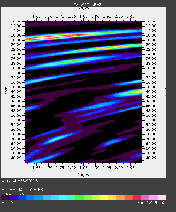
| Estimated Moho Depth: |
16.5 km |
| Estimated Crust Vp/Vs: |
1.72 |
| Assumed Crust Vp: |
6.566 km/s |
| Estimated Crust Vs: |
3.823 km/s |
| Estimated Crust Poisson's Ratio: |
0.24 |
|
| Radial Match: |
83.66118 % |
| Radial Bump: |
400 |
| Transverse Match: |
92.078606 % |
| Transverse Bump: |
400 |
| SOD ConfigId: |
405110 |
| Insert Time: |
2011-12-29 10:07:40.830 +0000 |
| GWidth: |
2.5 |
| Max Bumps: |
400 |
| Tol: |
0.001 |
|

Signal To Noise
| Channel | StoN | STA | LTA |
| TA:N02D: :BHZ:20110729T07:53:24.825007Z | 14.460978 | 5.2712403E-6 | 3.645148E-7 |
| TA:N02D: :BHN:20110729T07:53:24.825007Z | 4.478359 | 1.2015031E-6 | 2.682909E-7 |
| TA:N02D: :BHE:20110729T07:53:24.825007Z | 2.8714464 | 8.1798885E-7 | 2.8486997E-7 |
| Arrivals |
| Ps | 1.8 SECOND |
| PpPs | 6.7 SECOND |
| PsPs/PpSs | 8.5 SECOND |


