You are here: Home > Network List > TA - USArray Transportable Network (new EarthScope stations) Stations List
> Station 832A Faith Ranch, Carrizo Springs, TX, USA > Earthquake Result Viewer
832A Faith Ranch, Carrizo Springs, TX, USA - Earthquake Result Viewer
| Earthquake location: |
South Of Fiji Islands |
| Earthquake latitude/longitude: |
-23.8/179.8 |
| Earthquake time(UTC): |
2011/07/29 (210) 07:42:22 GMT |
| Earthquake Depth: |
523 km |
| Earthquake Magnitude: |
6.2 MB, 6.7 MW, 6.7 MW |
| Earthquake Catalog/Contributor: |
WHDF/NEIC |
|
| Network: |
TA USArray Transportable Network (new EarthScope stations) |
| Station: |
832A Faith Ranch, Carrizo Springs, TX, USA |
| Lat/Lon: |
28.28 N/99.97 W |
| Elevation: |
238 m |
|
| Distance: |
93.0 deg |
| Az: |
60.508 deg |
| Baz: |
244.705 deg |
| Ray Param: |
0.040921696 |
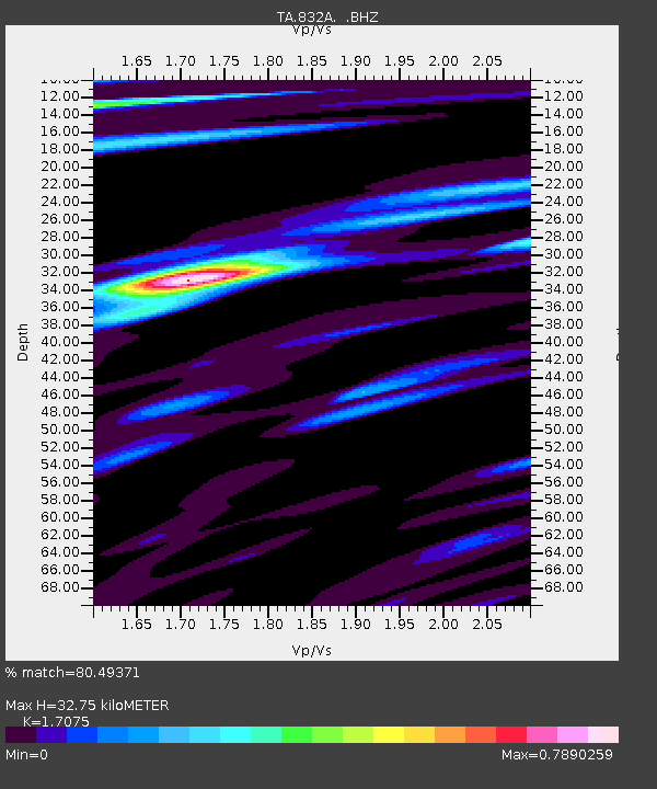
| Estimated Moho Depth: |
32.75 km |
| Estimated Crust Vp/Vs: |
1.71 |
| Assumed Crust Vp: |
6.347 km/s |
| Estimated Crust Vs: |
3.717 km/s |
| Estimated Crust Poisson's Ratio: |
0.24 |
|
| Radial Match: |
80.49371 % |
| Radial Bump: |
359 |
| Transverse Match: |
78.57617 % |
| Transverse Bump: |
400 |
| SOD ConfigId: |
405110 |
| Insert Time: |
2011-12-29 10:09:53.801 +0000 |
| GWidth: |
2.5 |
| Max Bumps: |
400 |
| Tol: |
0.001 |
|
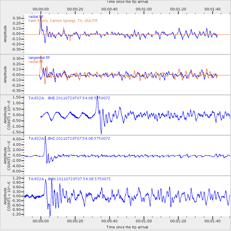
Signal To Noise
| Channel | StoN | STA | LTA |
| TA:832A: :BHZ:20110729T07:54:08.575007Z | 16.094646 | 2.5896213E-6 | 1.6089955E-7 |
| TA:832A: :BHN:20110729T07:54:08.575007Z | 7.1400385 | 4.8625003E-7 | 6.810188E-8 |
| TA:832A: :BHE:20110729T07:54:08.575007Z | 3.4101152 | 6.532243E-7 | 1.915549E-7 |
| Arrivals |
| Ps | 3.7 SECOND |
| PpPs | 14 SECOND |
| PsPs/PpSs | 17 SECOND |


