You are here: Home > Network List > TA - USArray Transportable Network (new EarthScope stations) Stations List
> Station H04D Lebanon, OR, USA > Earthquake Result Viewer
H04D Lebanon, OR, USA - Earthquake Result Viewer
| Earthquake location: |
South Of Fiji Islands |
| Earthquake latitude/longitude: |
-23.8/179.8 |
| Earthquake time(UTC): |
2011/07/29 (210) 07:42:22 GMT |
| Earthquake Depth: |
523 km |
| Earthquake Magnitude: |
6.2 MB, 6.7 MW, 6.7 MW |
| Earthquake Catalog/Contributor: |
WHDF/NEIC |
|
| Network: |
TA USArray Transportable Network (new EarthScope stations) |
| Station: |
H04D Lebanon, OR, USA |
| Lat/Lon: |
44.52 N/122.74 W |
| Elevation: |
284 m |
|
| Distance: |
85.9 deg |
| Az: |
37.219 deg |
| Baz: |
230.771 deg |
| Ray Param: |
0.042984746 |
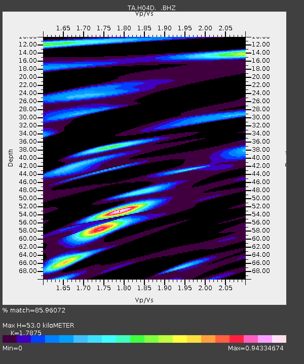
| Estimated Moho Depth: |
53.0 km |
| Estimated Crust Vp/Vs: |
1.79 |
| Assumed Crust Vp: |
6.566 km/s |
| Estimated Crust Vs: |
3.673 km/s |
| Estimated Crust Poisson's Ratio: |
0.27 |
|
| Radial Match: |
85.96072 % |
| Radial Bump: |
400 |
| Transverse Match: |
85.99803 % |
| Transverse Bump: |
400 |
| SOD ConfigId: |
405110 |
| Insert Time: |
2011-12-29 10:12:38.340 +0000 |
| GWidth: |
2.5 |
| Max Bumps: |
400 |
| Tol: |
0.001 |
|

Signal To Noise
| Channel | StoN | STA | LTA |
| TA:H04D: :BHZ:20110729T07:53:35.599971Z | 31.177662 | 7.620255E-6 | 2.4441394E-7 |
| TA:H04D: :BHN:20110729T07:53:35.599971Z | 4.8002954 | 1.4740586E-6 | 3.0707665E-7 |
| TA:H04D: :BHE:20110729T07:53:35.599971Z | 3.7535415 | 9.99326E-7 | 2.662355E-7 |
| Arrivals |
| Ps | 6.5 SECOND |
| PpPs | 22 SECOND |
| PsPs/PpSs | 28 SECOND |


