You are here: Home > Network List > UW - Pacific Northwest Regional Seismic Network Stations List
> Station UMAT Pilot Rock, OR, USA > Earthquake Result Viewer
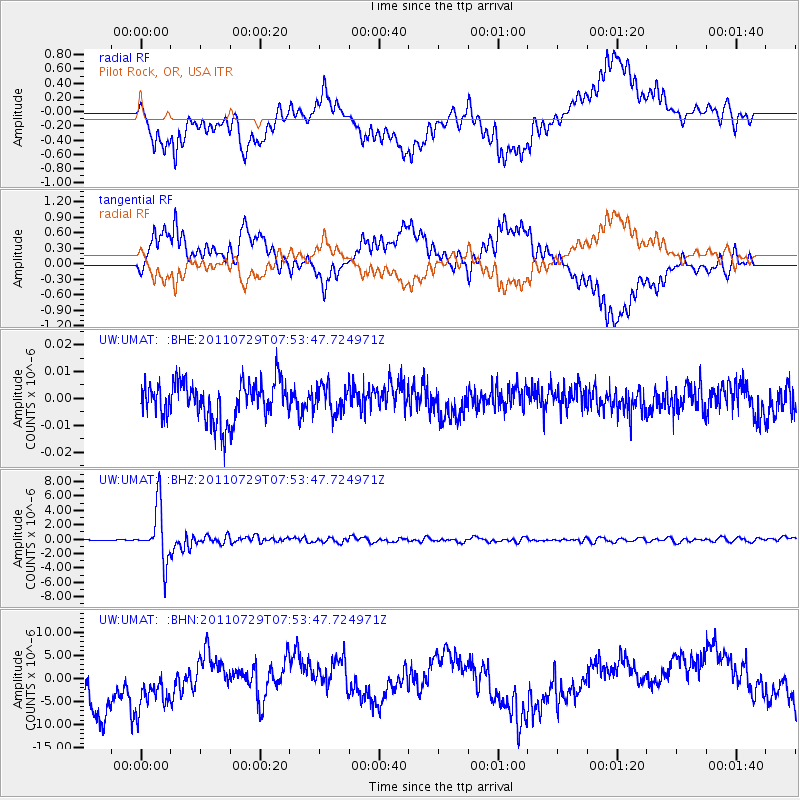
UMAT Pilot Rock, OR, USA - Earthquake Result Viewer
*The percent match for this event was below the threshold and hence no stack was calculated.
| Earthquake location: |
South Of Fiji Islands |
| Earthquake latitude/longitude: |
-23.8/179.8 |
| Earthquake time(UTC): |
2011/07/29 (210) 07:42:22 GMT |
| Earthquake Depth: |
523 km |
| Earthquake Magnitude: |
6.2 MB, 6.7 MW, 6.7 MW |
| Earthquake Catalog/Contributor: |
WHDF/NEIC |
|
| Network: |
UW Pacific Northwest Regional Seismic Network |
| Station: |
UMAT Pilot Rock, OR, USA |
| Lat/Lon: |
45.29 N/118.96 W |
| Elevation: |
1318 m |
|
| Distance: |
88.5 deg |
| Az: |
38.264 deg |
| Baz: |
233.481 deg |
| Ray Param: |
$rayparam |
*The percent match for this event was below the threshold and hence was not used in the summary stack. |
|
| Radial Match: |
38.106754 % |
| Radial Bump: |
400 |
| Transverse Match: |
38.14472 % |
| Transverse Bump: |
400 |
| SOD ConfigId: |
405110 |
| Insert Time: |
2011-12-29 10:16:35.791 +0000 |
| GWidth: |
2.5 |
| Max Bumps: |
400 |
| Tol: |
0.001 |
|
Signal To Noise
| Channel | StoN | STA | LTA |
| UW:UMAT: :BHZ:20110729T07:53:47.724971Z | 95.96739 | 3.7415389E-6 | 3.8987604E-8 |
| UW:UMAT: :BHN:20110729T07:53:47.724971Z | 1.2020844 | 6.1921264E-6 | 5.151158E-6 |
| UW:UMAT: :BHE:20110729T07:53:47.724971Z | 0.68830436 | 4.907527E-9 | 7.129879E-9 |
| Arrivals |
| Ps | |
| PpPs | |
| PsPs/PpSs | |


