You are here: Home > Network List > TA - USArray Transportable Network (new EarthScope stations) Stations List
> Station E62A Clayton Lake, ME, USA > Earthquake Result Viewer
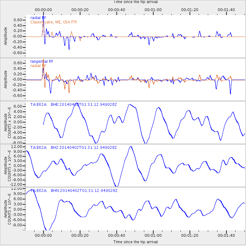
E62A Clayton Lake, ME, USA - Earthquake Result Viewer
*The percent match for this event was below the threshold and hence no stack was calculated.
| Earthquake location: |
Near Coast Of Northern Chile |
| Earthquake latitude/longitude: |
-19.6/-70.9 |
| Earthquake time(UTC): |
2014/04/02 (092) 01:20:59 GMT |
| Earthquake Depth: |
22 km |
| Earthquake Magnitude: |
5.2 mb |
| Earthquake Catalog/Contributor: |
ISC/ISC |
|
| Network: |
TA USArray Transportable Network (new EarthScope stations) |
| Station: |
E62A Clayton Lake, ME, USA |
| Lat/Lon: |
46.62 N/69.52 W |
| Elevation: |
356 m |
|
| Distance: |
65.9 deg |
| Az: |
1.062 deg |
| Baz: |
181.453 deg |
| Ray Param: |
$rayparam |
*The percent match for this event was below the threshold and hence was not used in the summary stack. |
|
| Radial Match: |
66.511185 % |
| Radial Bump: |
400 |
| Transverse Match: |
59.829105 % |
| Transverse Bump: |
400 |
| SOD ConfigId: |
3390531 |
| Insert Time: |
2019-04-11 00:45:58.701 +0000 |
| GWidth: |
2.5 |
| Max Bumps: |
400 |
| Tol: |
0.001 |
|
Signal To Noise
| Channel | StoN | STA | LTA |
| TA:E62A: :BHZ:20140402T01:31:12.949028Z | 0.5581645 | 3.638179E-6 | 6.518113E-6 |
| TA:E62A: :BHN:20140402T01:31:12.949028Z | 1.7685846 | 1.1061734E-5 | 6.2545687E-6 |
| TA:E62A: :BHE:20140402T01:31:12.949028Z | 1.5860746 | 5.804957E-6 | 3.659952E-6 |
| Arrivals |
| Ps | |
| PpPs | |
| PsPs/PpSs | |


