You are here: Home > Network List > CI - Caltech Regional Seismic Network Stations List
> Station SMM Simmler, CA, USA > Earthquake Result Viewer
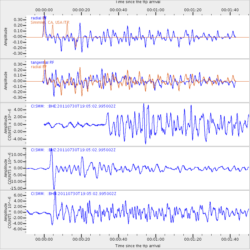
SMM Simmler, CA, USA - Earthquake Result Viewer
*The percent match for this event was below the threshold and hence no stack was calculated.
| Earthquake location: |
Near East Coast Of Honshu, Japan |
| Earthquake latitude/longitude: |
36.9/141.0 |
| Earthquake time(UTC): |
2011/07/30 (211) 18:53:49 GMT |
| Earthquake Depth: |
30 km |
| Earthquake Magnitude: |
6.4 MB, 6.0 MS, 6.5 MW, 6.4 MW |
| Earthquake Catalog/Contributor: |
WHDF/NEIC |
|
| Network: |
CI Caltech Regional Seismic Network |
| Station: |
SMM Simmler, CA, USA |
| Lat/Lon: |
35.31 N/120.00 W |
| Elevation: |
599 m |
|
| Distance: |
76.0 deg |
| Az: |
56.332 deg |
| Baz: |
305.382 deg |
| Ray Param: |
$rayparam |
*The percent match for this event was below the threshold and hence was not used in the summary stack. |
|
| Radial Match: |
86.57299 % |
| Radial Bump: |
400 |
| Transverse Match: |
80.85089 % |
| Transverse Bump: |
400 |
| SOD ConfigId: |
408116 |
| Insert Time: |
2012-01-01 00:56:24.540 +0000 |
| GWidth: |
2.5 |
| Max Bumps: |
400 |
| Tol: |
0.001 |
|
Signal To Noise
| Channel | StoN | STA | LTA |
| CI:SMM: :BHZ:20110730T19:05:02.995002Z | 23.652872 | 5.640025E-6 | 2.384499E-7 |
| CI:SMM: :BHN:20110730T19:05:02.995002Z | 4.253251 | 1.5007142E-6 | 3.5283932E-7 |
| CI:SMM: :BHE:20110730T19:05:02.995002Z | 3.2536461 | 1.2555525E-6 | 3.8589093E-7 |
| Arrivals |
| Ps | |
| PpPs | |
| PsPs/PpSs | |


