You are here: Home > Network List > CI - Caltech Regional Seismic Network Stations List
> Station TUQ Turquiose Mountain, Baker, CA, USA > Earthquake Result Viewer
TUQ Turquiose Mountain, Baker, CA, USA - Earthquake Result Viewer
| Earthquake location: |
Near East Coast Of Honshu, Japan |
| Earthquake latitude/longitude: |
36.9/141.0 |
| Earthquake time(UTC): |
2011/07/30 (211) 18:53:49 GMT |
| Earthquake Depth: |
30 km |
| Earthquake Magnitude: |
6.4 MB, 6.0 MS, 6.5 MW, 6.4 MW |
| Earthquake Catalog/Contributor: |
WHDF/NEIC |
|
| Network: |
CI Caltech Regional Seismic Network |
| Station: |
TUQ Turquiose Mountain, Baker, CA, USA |
| Lat/Lon: |
35.44 N/115.92 W |
| Elevation: |
1350 m |
|
| Distance: |
78.6 deg |
| Az: |
54.211 deg |
| Baz: |
307.264 deg |
| Ray Param: |
0.04946412 |
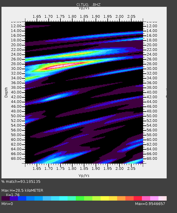
| Estimated Moho Depth: |
28.5 km |
| Estimated Crust Vp/Vs: |
1.76 |
| Assumed Crust Vp: |
6.276 km/s |
| Estimated Crust Vs: |
3.566 km/s |
| Estimated Crust Poisson's Ratio: |
0.26 |
|
| Radial Match: |
93.185135 % |
| Radial Bump: |
324 |
| Transverse Match: |
84.16455 % |
| Transverse Bump: |
400 |
| SOD ConfigId: |
408116 |
| Insert Time: |
2012-01-01 00:57:39.860 +0000 |
| GWidth: |
2.5 |
| Max Bumps: |
400 |
| Tol: |
0.001 |
|
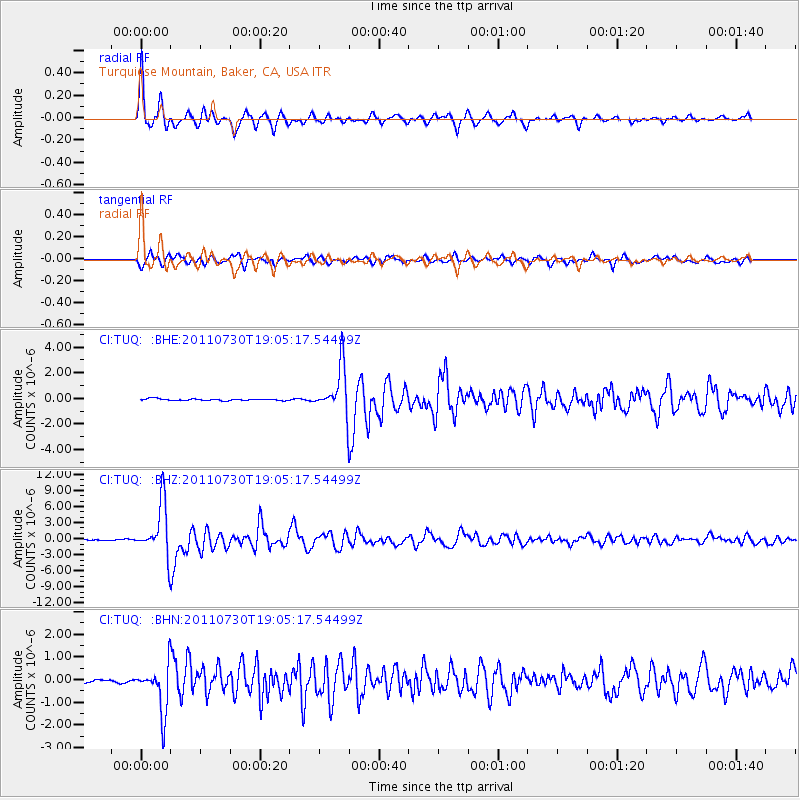
Signal To Noise
| Channel | StoN | STA | LTA |
| CI:TUQ: :BHZ:20110730T19:05:17.54499Z | 54.977943 | 4.8833554E-6 | 8.88239E-8 |
| CI:TUQ: :BHN:20110730T19:05:17.54499Z | 10.003759 | 1.0334751E-6 | 1.0330867E-7 |
| CI:TUQ: :BHE:20110730T19:05:17.54499Z | 27.38084 | 1.8567246E-6 | 6.781109E-8 |
| Arrivals |
| Ps | 3.6 SECOND |
| PpPs | 12 SECOND |
| PsPs/PpSs | 16 SECOND |


