You are here: Home > Network List > CI - Caltech Regional Seismic Network Stations List
> Station IKP In-Ko-Pah, Jacumba, CA, USA > Earthquake Result Viewer
IKP In-Ko-Pah, Jacumba, CA, USA - Earthquake Result Viewer
| Earthquake location: |
Near East Coast Of Honshu, Japan |
| Earthquake latitude/longitude: |
36.9/141.0 |
| Earthquake time(UTC): |
2011/07/30 (211) 18:53:49 GMT |
| Earthquake Depth: |
30 km |
| Earthquake Magnitude: |
6.4 MB, 6.0 MS, 6.5 MW, 6.4 MW |
| Earthquake Catalog/Contributor: |
WHDF/NEIC |
|
| Network: |
CI Caltech Regional Seismic Network |
| Station: |
IKP In-Ko-Pah, Jacumba, CA, USA |
| Lat/Lon: |
32.65 N/116.11 W |
| Elevation: |
906 m |
|
| Distance: |
80.2 deg |
| Az: |
56.551 deg |
| Baz: |
307.59 deg |
| Ray Param: |
0.048395112 |
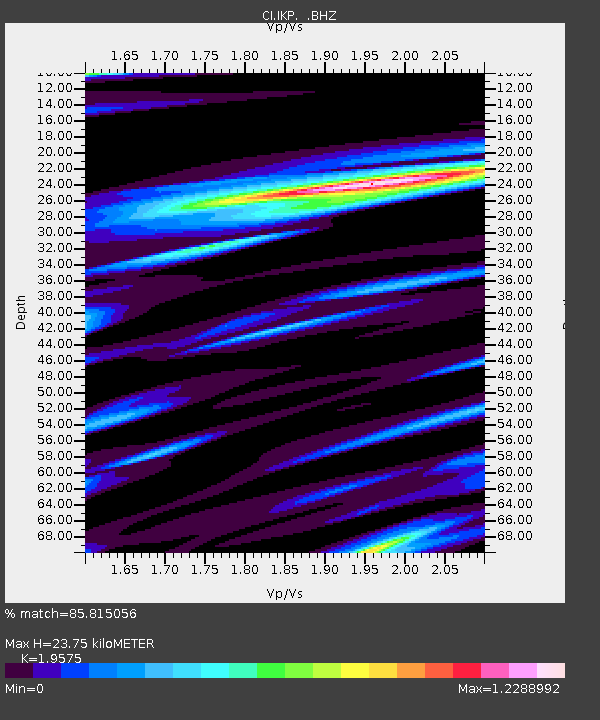
| Estimated Moho Depth: |
23.75 km |
| Estimated Crust Vp/Vs: |
1.96 |
| Assumed Crust Vp: |
6.264 km/s |
| Estimated Crust Vs: |
3.2 km/s |
| Estimated Crust Poisson's Ratio: |
0.32 |
|
| Radial Match: |
85.815056 % |
| Radial Bump: |
400 |
| Transverse Match: |
81.19082 % |
| Transverse Bump: |
400 |
| SOD ConfigId: |
408116 |
| Insert Time: |
2012-01-01 00:58:19.355 +0000 |
| GWidth: |
2.5 |
| Max Bumps: |
400 |
| Tol: |
0.001 |
|

Signal To Noise
| Channel | StoN | STA | LTA |
| CI:IKP: :BHZ:20110730T19:05:26.04499Z | 20.11242 | 3.5696182E-6 | 1.7748327E-7 |
| CI:IKP: :BHN:20110730T19:05:26.04499Z | 4.628215 | 1.0095289E-6 | 2.181249E-7 |
| CI:IKP: :BHE:20110730T19:05:26.04499Z | 5.1796265 | 1.3045726E-6 | 2.5186614E-7 |
| Arrivals |
| Ps | 3.7 SECOND |
| PpPs | 11 SECOND |
| PsPs/PpSs | 15 SECOND |


