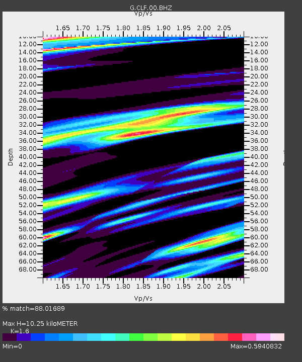
CLF Chambon la Foret observatory, France - Earthquake Result Viewer
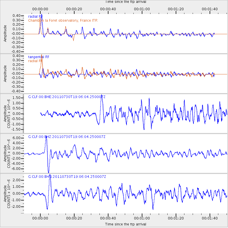
Earthquake location: Near East Coast Of Honshu, Japan
Earthquake latitude/longitude: 36.9/141.0
Earthquake time(UTC): 2011/07/30 (211) 18:53:49 GMT
Earthquake Depth: 30 km
Earthquake Magnitude: 6.4 MB, 6.0 MS, 6.5 MW, 6.4 MW
Earthquake Catalog/Contributor: WHDF/NEIC
Network: G GEOSCOPE
Station: CLF Chambon la Foret observatory, France
Lat/Lon: 48.03 N/2.26 E
Elevation: 145 m
Distance: 87.7 deg
Az: 333.679 deg
Baz: 31.951 deg
Ray Param: 0.04307307
Estimated Moho Depth: 10.25 km
Estimated Crust Vp/Vs: 1.60
Assumed Crust Vp: 6.12 km/s
Estimated Crust Vs: 3.825 km/s
Estimated Crust Poisson's Ratio: 0.18
Radial Match: 88.01689 %
Radial Bump: 386
Transverse Match: 81.65192 %
Transverse Bump: 400
SOD ConfigId: 408116
Insert Time: 2012-01-01 00:59:18.415 +0000
GWidth: 2.5
Max Bumps: 400
Tol: 0.001

Signal To Noise

ChannelStoNSTALTA
G:CLF:00:BHZ:20110730T19:06:04.250007Z20.7400653.1433817E-61.5156085E-7
G:CLF:00:BHN:20110730T19:06:04.250007Z4.68627458.9264404E-71.9048052E-7
G:CLF:00:BHE:20110730T19:06:04.250007Z3.27095324.4360905E-71.3562072E-7
Arrivals
Ps1.0 SECOND
PpPs4.3 SECOND
PsPs/PpSs5.3 SECOND