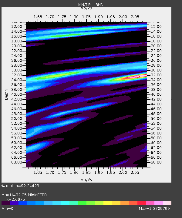
TIP Timpagrande, Italy - Earthquake Result Viewer
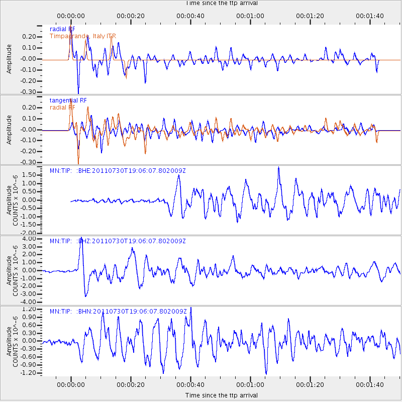
Earthquake location: Near East Coast Of Honshu, Japan
Earthquake latitude/longitude: 36.9/141.0
Earthquake time(UTC): 2011/07/30 (211) 18:53:49 GMT
Earthquake Depth: 30 km
Earthquake Magnitude: 6.4 MB, 6.0 MS, 6.5 MW, 6.4 MW
Earthquake Catalog/Contributor: WHDF/NEIC
Network: MN MEDNET Project
Station: TIP Timpagrande, Italy
Lat/Lon: 39.18 N/16.76 E
Elevation: 789 m
Distance: 88.5 deg
Az: 319.979 deg
Baz: 41.518 deg
Ray Param: 0.04251872
Estimated Moho Depth: 32.25 km
Estimated Crust Vp/Vs: 2.07
Assumed Crust Vp: 6.1 km/s
Estimated Crust Vs: 2.95 km/s
Estimated Crust Poisson's Ratio: 0.35
Radial Match: 92.24428 %
Radial Bump: 397
Transverse Match: 87.42006 %
Transverse Bump: 400
SOD ConfigId: 408116
Insert Time: 2012-01-01 01:04:28.235 +0000
GWidth: 2.5
Max Bumps: 400
Tol: 0.001

Signal To Noise

ChannelStoNSTALTA
MN:TIP: :BHZ:20110730T19:06:07.802009Z28.3586651.8321064E-66.460482E-8
MN:TIP: :BHN:20110730T19:06:07.802009Z5.6322773.0997978E-75.5036317E-8
MN:TIP: :BHE:20110730T19:06:07.802009Z6.6186153.865901E-75.840952E-8
Arrivals
Ps5.7 SECOND
PpPs16 SECOND
PsPs/PpSs22 SECOND