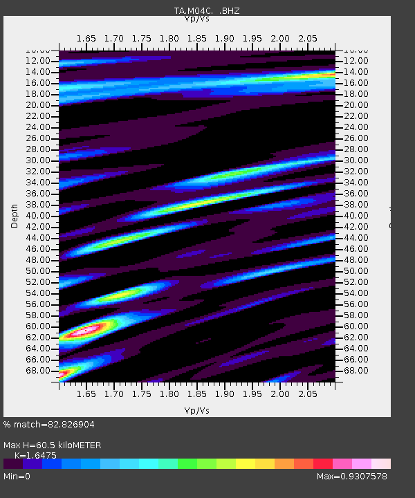
M04C Macdoel, CA, USA - Earthquake Result Viewer
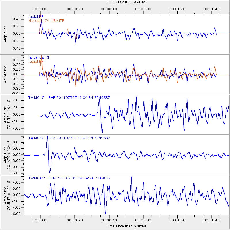
Earthquake location: Near East Coast Of Honshu, Japan
Earthquake latitude/longitude: 36.9/141.0
Earthquake time(UTC): 2011/07/30 (211) 18:53:49 GMT
Earthquake Depth: 30 km
Earthquake Magnitude: 6.4 MB, 6.0 MS, 6.5 MW, 6.4 MW
Earthquake Catalog/Contributor: WHDF/NEIC
Network: TA USArray Transportable Network (new EarthScope stations)
Station: M04C Macdoel, CA, USA
Lat/Lon: 41.78 N/121.84 W
Elevation: 1391 m
Distance: 71.2 deg
Az: 51.608 deg
Baz: 302.902 deg
Ray Param: 0.054438174
Estimated Moho Depth: 60.5 km
Estimated Crust Vp/Vs: 1.65
Assumed Crust Vp: 6.566 km/s
Estimated Crust Vs: 3.986 km/s
Estimated Crust Poisson's Ratio: 0.21
Radial Match: 82.826904 %
Radial Bump: 400
Transverse Match: 82.60874 %
Transverse Bump: 400
SOD ConfigId: 408116
Insert Time: 2012-01-01 01:07:35.171 +0000
GWidth: 2.5
Max Bumps: 400
Tol: 0.001

Signal To Noise

ChannelStoNSTALTA
TA:M04C: :BHZ:20110730T19:04:34.724983Z25.832765.8468368E-62.263342E-7
TA:M04C: :BHN:20110730T19:04:34.724983Z4.49027441.2592493E-62.8043928E-7
TA:M04C: :BHE:20110730T19:04:34.724983Z3.74810271.788913E-64.7728497E-7
Arrivals
Ps6.2 SECOND
PpPs23 SECOND
PsPs/PpSs30 SECOND