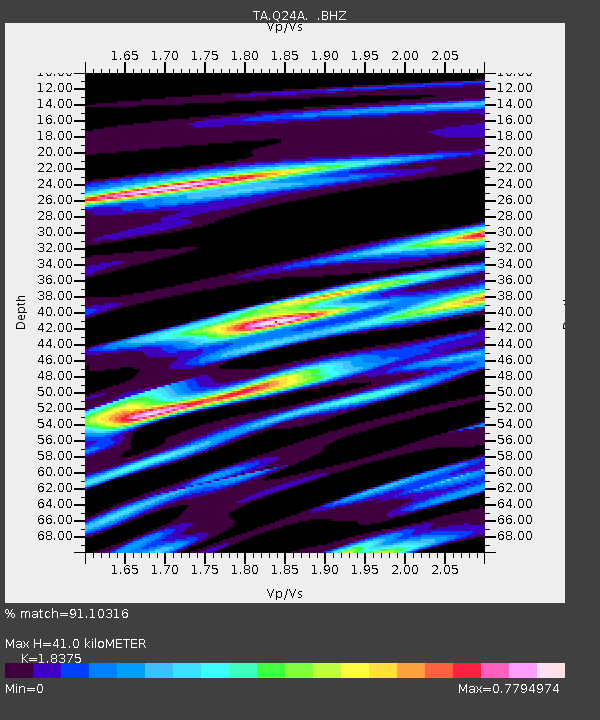
Q24A Divide, CO, USA - Earthquake Result Viewer

Earthquake location: Near East Coast Of Honshu, Japan
Earthquake latitude/longitude: 36.9/141.0
Earthquake time(UTC): 2011/07/30 (211) 18:53:49 GMT
Earthquake Depth: 30 km
Earthquake Magnitude: 6.4 MB, 6.0 MS, 6.5 MW, 6.4 MW
Earthquake Catalog/Contributor: WHDF/NEIC
Network: TA USArray Transportable Network (new EarthScope stations)
Station: Q24A Divide, CO, USA
Lat/Lon: 38.96 N/105.15 W
Elevation: 2775 m
Distance: 83.0 deg
Az: 45.902 deg
Baz: 312.438 deg
Ray Param: 0.046457443
Estimated Moho Depth: 41.0 km
Estimated Crust Vp/Vs: 1.84
Assumed Crust Vp: 6.159 km/s
Estimated Crust Vs: 3.352 km/s
Estimated Crust Poisson's Ratio: 0.29
Radial Match: 91.10316 %
Radial Bump: 400
Transverse Match: 79.263664 %
Transverse Bump: 400
SOD ConfigId: 408116
Insert Time: 2012-01-01 01:08:33.954 +0000
GWidth: 2.5
Max Bumps: 400
Tol: 0.001

Signal To Noise

ChannelStoNSTALTA
TA:Q24A: :BHZ:20110730T19:05:40.750007Z42.7184263.264673E-67.642307E-8
TA:Q24A: :BHN:20110730T19:05:40.750007Z5.3143539.98926E-71.8796757E-7
TA:Q24A: :BHE:20110730T19:05:40.750007Z3.66921456.0499843E-71.64885E-7
Arrivals
Ps5.7 SECOND
PpPs18 SECOND
PsPs/PpSs24 SECOND