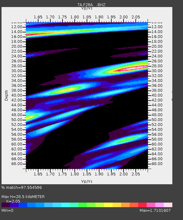
F29A Eureka, SD, USA - Earthquake Result Viewer

Earthquake location: Near East Coast Of Honshu, Japan
Earthquake latitude/longitude: 36.9/141.0
Earthquake time(UTC): 2011/07/30 (211) 18:53:49 GMT
Earthquake Depth: 30 km
Earthquake Magnitude: 6.4 MB, 6.0 MS, 6.5 MW, 6.4 MW
Earthquake Catalog/Contributor: WHDF/NEIC
Network: TA USArray Transportable Network (new EarthScope stations)
Station: F29A Eureka, SD, USA
Lat/Lon: 45.83 N/99.83 W
Elevation: 575 m
Distance: 81.1 deg
Az: 38.144 deg
Baz: 314.947 deg
Ray Param: 0.0477759
Estimated Moho Depth: 28.5 km
Estimated Crust Vp/Vs: 2.05
Assumed Crust Vp: 6.53 km/s
Estimated Crust Vs: 3.186 km/s
Estimated Crust Poisson's Ratio: 0.34
Radial Match: 97.554596 %
Radial Bump: 272
Transverse Match: 89.2476 %
Transverse Bump: 388
SOD ConfigId: 408116
Insert Time: 2012-01-01 01:09:43.165 +0000
GWidth: 2.5
Max Bumps: 400
Tol: 0.001

Signal To Noise

ChannelStoNSTALTA
TA:F29A: :BHZ:20110730T19:05:30.875007Z60.0491879.007135E-61.4999596E-7
TA:F29A: :BHN:20110730T19:05:30.875007Z9.06734853.2695036E-63.6057992E-7
TA:F29A: :BHE:20110730T19:05:30.875007Z6.8042832.8238778E-64.1501474E-7
Arrivals
Ps4.7 SECOND
PpPs13 SECOND
PsPs/PpSs18 SECOND