You are here: Home > Network List > TA - USArray Transportable Network (new EarthScope stations) Stations List
> Station O31A Woollen Ranch, Alma, NE, USA > Earthquake Result Viewer
O31A Woollen Ranch, Alma, NE, USA - Earthquake Result Viewer

| Earthquake location: |
Near East Coast Of Honshu, Japan |
| Earthquake latitude/longitude: |
36.9/141.0 |
| Earthquake time(UTC): |
2011/07/30 (211) 18:53:49 GMT |
| Earthquake Depth: |
30 km |
| Earthquake Magnitude: |
6.4 MB, 6.0 MS, 6.5 MW, 6.4 MW |
| Earthquake Catalog/Contributor: |
WHDF/NEIC |
|
| Network: |
TA USArray Transportable Network (new EarthScope stations) |
| Station: |
O31A Woollen Ranch, Alma, NE, USA |
| Lat/Lon: |
40.15 N/99.33 W |
| Elevation: |
631 m |
|
| Distance: |
85.4 deg |
| Az: |
41.899 deg |
| Baz: |
315.729 deg |
| Ray Param: |
0.04474563 |
| Estimated Moho Depth: |
38.5 km |
| Estimated Crust Vp/Vs: |
1.94 |
| Assumed Crust Vp: |
6.53 km/s |
| Estimated Crust Vs: |
3.366 km/s |
| Estimated Crust Poisson's Ratio: |
0.32 |
|
| Radial Match: |
93.67171 % |
| Radial Bump: |
326 |
| Transverse Match: |
85.62057 % |
| Transverse Bump: |
400 |
| SOD ConfigId: |
408116 |
| Insert Time: |
2012-01-01 01:10:11.693 +0000 |
| GWidth: |
2.5 |
| Max Bumps: |
400 |
| Tol: |
0.001 |
|
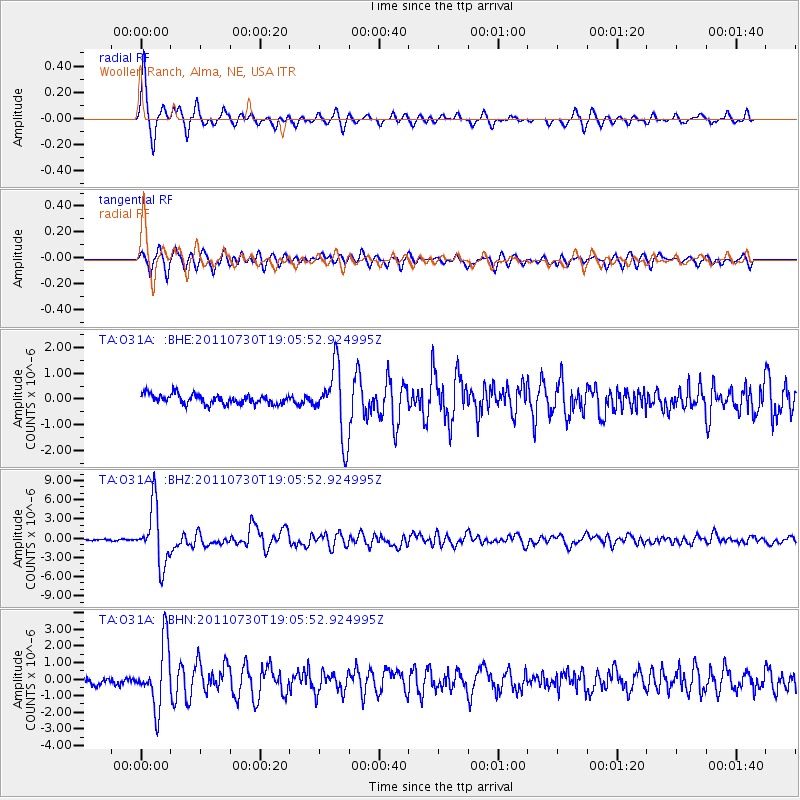
Signal To Noise
| Channel | StoN | STA | LTA |
| TA:O31A: :BHZ:20110730T19:05:52.924995Z | 48.189312 | 4.515198E-6 | 9.3697075E-8 |
| TA:O31A: :BHN:20110730T19:05:52.924995Z | 7.854691 | 1.8819378E-6 | 2.3959413E-7 |
| TA:O31A: :BHE:20110730T19:05:52.924995Z | 7.1808643 | 1.3433935E-6 | 1.8707964E-7 |
| Arrivals |
| Ps | 5.7 SECOND |
| PpPs | 17 SECOND |
| PsPs/PpSs | 23 SECOND |


