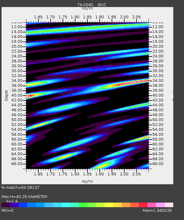
K04D Chiloquin, OR, USA - Earthquake Result Viewer
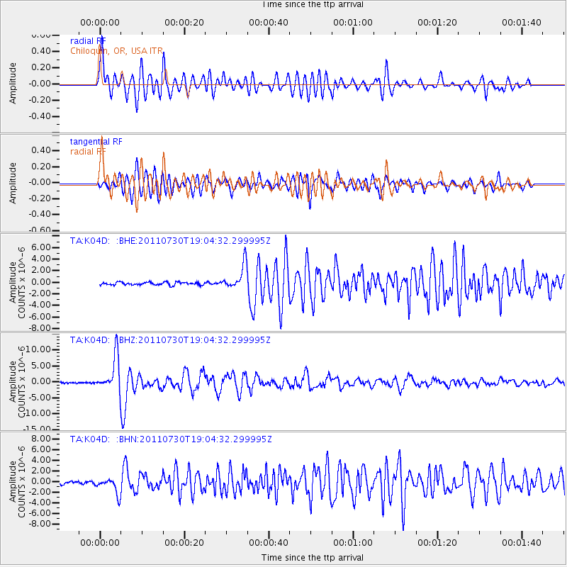
Earthquake location: Near East Coast Of Honshu, Japan
Earthquake latitude/longitude: 36.9/141.0
Earthquake time(UTC): 2011/07/30 (211) 18:53:49 GMT
Earthquake Depth: 30 km
Earthquake Magnitude: 6.4 MB, 6.0 MS, 6.5 MW, 6.4 MW
Earthquake Catalog/Contributor: WHDF/NEIC
Network: TA USArray Transportable Network (new EarthScope stations)
Station: K04D Chiloquin, OR, USA
Lat/Lon: 42.62 N/121.75 W
Elevation: 1315 m
Distance: 70.8 deg
Az: 50.823 deg
Baz: 302.704 deg
Ray Param: 0.0546964
Estimated Moho Depth: 40.25 km
Estimated Crust Vp/Vs: 1.60
Assumed Crust Vp: 6.597 km/s
Estimated Crust Vs: 4.123 km/s
Estimated Crust Poisson's Ratio: 0.18
Radial Match: 84.59157 %
Radial Bump: 400
Transverse Match: 82.31232 %
Transverse Bump: 400
SOD ConfigId: 408116
Insert Time: 2012-01-01 01:10:49.914 +0000
GWidth: 2.5
Max Bumps: 400
Tol: 0.001

Signal To Noise

ChannelStoNSTALTA
TA:K04D: :BHZ:20110730T19:04:32.299995Z41.5861475.5899663E-61.3441895E-7
TA:K04D: :BHN:20110730T19:04:32.299995Z5.32029441.5919928E-62.992302E-7
TA:K04D: :BHE:20110730T19:04:32.299995Z9.2034692.22649E-62.4191857E-7
Arrivals
Ps3.8 SECOND
PpPs15 SECOND
PsPs/PpSs19 SECOND