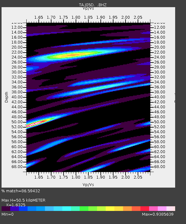
J05D Fort Rock, OR, USA - Earthquake Result Viewer

Earthquake location: Near East Coast Of Honshu, Japan
Earthquake latitude/longitude: 36.9/141.0
Earthquake time(UTC): 2011/07/30 (211) 18:53:49 GMT
Earthquake Depth: 30 km
Earthquake Magnitude: 6.4 MB, 6.0 MS, 6.5 MW, 6.4 MW
Earthquake Catalog/Contributor: WHDF/NEIC
Network: TA USArray Transportable Network (new EarthScope stations)
Station: J05D Fort Rock, OR, USA
Lat/Lon: 43.28 N/121.23 W
Elevation: 1541 m
Distance: 70.8 deg
Az: 50.017 deg
Baz: 302.791 deg
Ray Param: 0.054720644
Estimated Moho Depth: 50.5 km
Estimated Crust Vp/Vs: 1.63
Assumed Crust Vp: 6.597 km/s
Estimated Crust Vs: 4.041 km/s
Estimated Crust Poisson's Ratio: 0.20
Radial Match: 86.59432 %
Radial Bump: 400
Transverse Match: 86.71845 %
Transverse Bump: 400
SOD ConfigId: 408116
Insert Time: 2012-01-01 01:11:02.390 +0000
GWidth: 2.5
Max Bumps: 400
Tol: 0.001

Signal To Noise

ChannelStoNSTALTA
TA:J05D: :BHZ:20110730T19:04:32.07502Z40.0364155.247911E-61.3107845E-7
TA:J05D: :BHN:20110730T19:04:32.07502Z5.71337567.488291E-71.3106597E-7
TA:J05D: :BHE:20110730T19:04:32.07502Z10.0773161.8345521E-61.8204769E-7
Arrivals
Ps5.0 SECOND
PpPs19 SECOND
PsPs/PpSs24 SECOND