You are here: Home > Network List > TA - USArray Transportable Network (new EarthScope stations) Stations List
> Station U33A Lingo Farm, Meno, OK, USA > Earthquake Result Viewer
U33A Lingo Farm, Meno, OK, USA - Earthquake Result Viewer
| Earthquake location: |
Near East Coast Of Honshu, Japan |
| Earthquake latitude/longitude: |
36.9/141.0 |
| Earthquake time(UTC): |
2011/07/30 (211) 18:53:49 GMT |
| Earthquake Depth: |
30 km |
| Earthquake Magnitude: |
6.4 MB, 6.0 MS, 6.5 MW, 6.4 MW |
| Earthquake Catalog/Contributor: |
WHDF/NEIC |
|
| Network: |
TA USArray Transportable Network (new EarthScope stations) |
| Station: |
U33A Lingo Farm, Meno, OK, USA |
| Lat/Lon: |
36.43 N/98.11 W |
| Elevation: |
393 m |
|
| Distance: |
88.8 deg |
| Az: |
43.785 deg |
| Baz: |
316.574 deg |
| Ray Param: |
0.042316217 |
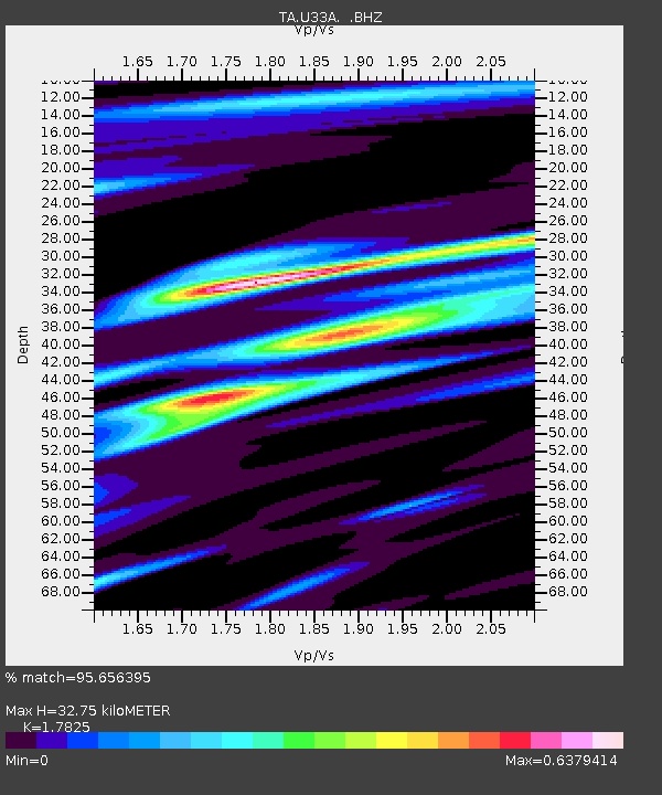
| Estimated Moho Depth: |
32.75 km |
| Estimated Crust Vp/Vs: |
1.78 |
| Assumed Crust Vp: |
6.426 km/s |
| Estimated Crust Vs: |
3.605 km/s |
| Estimated Crust Poisson's Ratio: |
0.27 |
|
| Radial Match: |
95.656395 % |
| Radial Bump: |
364 |
| Transverse Match: |
86.35038 % |
| Transverse Bump: |
400 |
| SOD ConfigId: |
408116 |
| Insert Time: |
2012-01-01 01:11:55.983 +0000 |
| GWidth: |
2.5 |
| Max Bumps: |
400 |
| Tol: |
0.001 |
|
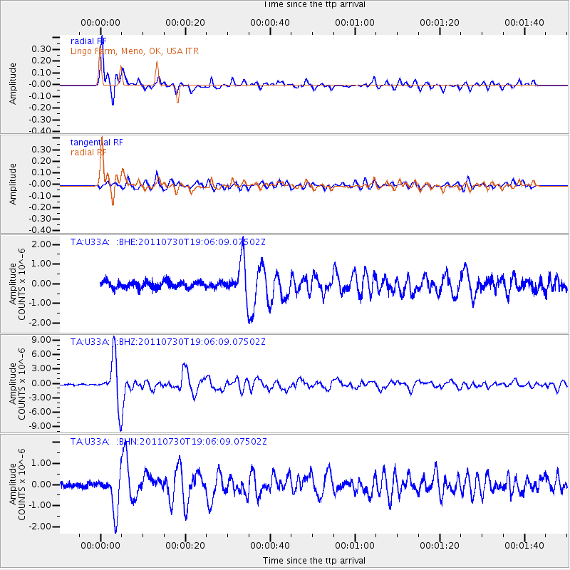
Signal To Noise
| Channel | StoN | STA | LTA |
| TA:U33A: :BHZ:20110730T19:06:09.07502Z | 61.022392 | 4.801786E-6 | 7.868892E-8 |
| TA:U33A: :BHN:20110730T19:06:09.07502Z | 6.1779957 | 8.890428E-7 | 1.4390473E-7 |
| TA:U33A: :BHE:20110730T19:06:09.07502Z | 5.45965 | 9.332899E-7 | 1.7094318E-7 |
| Arrivals |
| Ps | 4.1 SECOND |
| PpPs | 14 SECOND |
| PsPs/PpSs | 18 SECOND |


