You are here: Home > Network List > TA - USArray Transportable Network (new EarthScope stations) Stations List
> Station W34A Bridge Creek, Tuttle, OK, USA > Earthquake Result Viewer
W34A Bridge Creek, Tuttle, OK, USA - Earthquake Result Viewer

| Earthquake location: |
Near East Coast Of Honshu, Japan |
| Earthquake latitude/longitude: |
36.9/141.0 |
| Earthquake time(UTC): |
2011/07/30 (211) 18:53:49 GMT |
| Earthquake Depth: |
30 km |
| Earthquake Magnitude: |
6.4 MB, 6.0 MS, 6.5 MW, 6.4 MW |
| Earthquake Catalog/Contributor: |
WHDF/NEIC |
|
| Network: |
TA USArray Transportable Network (new EarthScope stations) |
| Station: |
W34A Bridge Creek, Tuttle, OK, USA |
| Lat/Lon: |
35.24 N/97.77 W |
| Elevation: |
428 m |
|
| Distance: |
89.8 deg |
| Az: |
44.404 deg |
| Baz: |
316.78 deg |
| Ray Param: |
0.041714698 |
| Estimated Moho Depth: |
15.5 km |
| Estimated Crust Vp/Vs: |
2.10 |
| Assumed Crust Vp: |
6.426 km/s |
| Estimated Crust Vs: |
3.064 km/s |
| Estimated Crust Poisson's Ratio: |
0.35 |
|
| Radial Match: |
86.55839 % |
| Radial Bump: |
400 |
| Transverse Match: |
87.10707 % |
| Transverse Bump: |
400 |
| SOD ConfigId: |
408116 |
| Insert Time: |
2012-01-01 01:12:06.022 +0000 |
| GWidth: |
2.5 |
| Max Bumps: |
400 |
| Tol: |
0.001 |
|
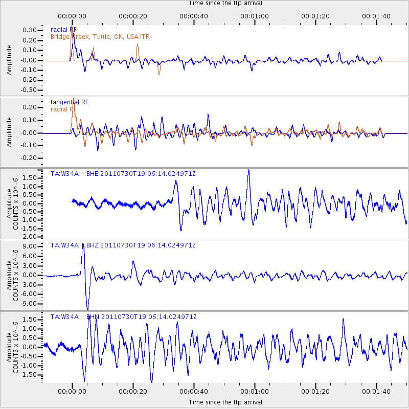
Signal To Noise
| Channel | StoN | STA | LTA |
| TA:W34A: :BHZ:20110730T19:06:14.024971Z | 42.240955 | 4.3040272E-6 | 1.01892276E-7 |
| TA:W34A: :BHN:20110730T19:06:14.024971Z | 2.920444 | 6.403592E-7 | 2.1926776E-7 |
| TA:W34A: :BHE:20110730T19:06:14.024971Z | 4.109411 | 5.8190955E-7 | 1.4160413E-7 |
| Arrivals |
| Ps | 2.7 SECOND |
| PpPs | 7.3 SECOND |
| PsPs/PpSs | 10 SECOND |


