434A Burnet, TX, USA - Earthquake Result Viewer
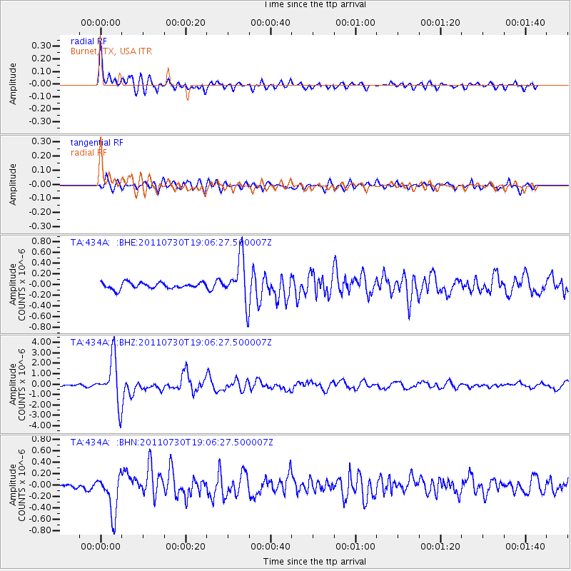
Earthquake location: Near East Coast Of Honshu, Japan
Earthquake latitude/longitude: 36.9/141.0
Earthquake time(UTC): 2011/07/30 (211) 18:53:49 GMT
Earthquake Depth: 30 km
Earthquake Magnitude: 6.4 MB, 6.0 MS, 6.5 MW, 6.4 MW
Earthquake Catalog/Contributor: WHDF/NEIC
Network: TA USArray Transportable Network (new EarthScope stations)
Station: 434A Burnet, TX, USA
Lat/Lon: 30.81 N/98.27 W
Elevation: 462 m
Distance: 92.7 deg
Az: 47.736 deg
Baz: 316.437 deg
Ray Param: 0.041391496
Estimated Moho Depth: 15.75 km
Estimated Crust Vp/Vs: 1.79
Assumed Crust Vp: 6.498 km/s
Estimated Crust Vs: 3.63 km/s
Estimated Crust Poisson's Ratio: 0.27
Radial Match: 90.41589 %
Radial Bump: 400
Transverse Match: 78.47956 %
Transverse Bump: 400
SOD ConfigId: 408116
Insert Time: 2012-01-01 01:13:22.694 +0000
GWidth: 2.5
Max Bumps: 400
Tol: 0.001

Signal To Noise

ChannelStoNSTALTA
TA:434A: :BHZ:20110730T19:06:27.500007Z31.99232.2247227E-66.953932E-8
TA:434A: :BHN:20110730T19:06:27.500007Z8.6611833.628099E-74.1889184E-8
TA:434A: :BHE:20110730T19:06:27.500007Z7.44596964.253773E-75.712853E-8
Arrivals
Ps2.0 SECOND
PpPs6.6 SECOND
PsPs/PpSs8.6 SECOND