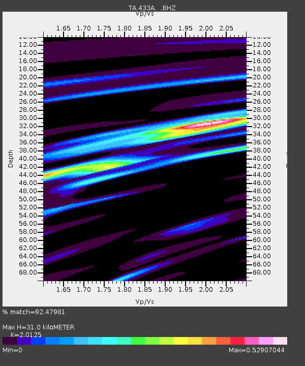
433A Art, TX, USA - Earthquake Result Viewer

Earthquake location: Near East Coast Of Honshu, Japan
Earthquake latitude/longitude: 36.9/141.0
Earthquake time(UTC): 2011/07/30 (211) 18:53:49 GMT
Earthquake Depth: 30 km
Earthquake Magnitude: 6.4 MB, 6.0 MS, 6.5 MW, 6.4 MW
Earthquake Catalog/Contributor: WHDF/NEIC
Network: TA USArray Transportable Network (new EarthScope stations)
Station: 433A Art, TX, USA
Lat/Lon: 30.75 N/99.09 W
Elevation: 447 m
Distance: 92.3 deg
Az: 48.288 deg
Baz: 315.994 deg
Ray Param: 0.041474484
Estimated Moho Depth: 31.0 km
Estimated Crust Vp/Vs: 2.01
Assumed Crust Vp: 6.498 km/s
Estimated Crust Vs: 3.229 km/s
Estimated Crust Poisson's Ratio: 0.34
Radial Match: 92.47981 %
Radial Bump: 400
Transverse Match: 83.74504 %
Transverse Bump: 400
SOD ConfigId: 408116
Insert Time: 2012-01-01 01:13:36.130 +0000
GWidth: 2.5
Max Bumps: 400
Tol: 0.001

Signal To Noise

ChannelStoNSTALTA
TA:433A: :BHZ:20110730T19:06:25.424995Z35.956112.2589475E-66.282514E-8
TA:433A: :BHN:20110730T19:06:25.424995Z10.3475414.6358832E-74.4801787E-8
TA:433A: :BHE:20110730T19:06:25.424995Z12.1192995.1032504E-74.2108464E-8
Arrivals
Ps4.9 SECOND
PpPs14 SECOND
PsPs/PpSs19 SECOND