You are here: Home > Network List > TA - USArray Transportable Network (new EarthScope stations) Stations List
> Station 135A Vickery Place, Crowley, TX, USA > Earthquake Result Viewer
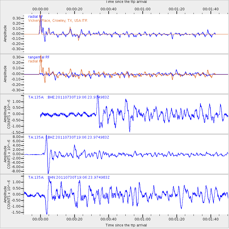
135A Vickery Place, Crowley, TX, USA - Earthquake Result Viewer

| Earthquake location: |
Near East Coast Of Honshu, Japan |
| Earthquake latitude/longitude: |
36.9/141.0 |
| Earthquake time(UTC): |
2011/07/30 (211) 18:53:49 GMT |
| Earthquake Depth: |
30 km |
| Earthquake Magnitude: |
6.4 MB, 6.0 MS, 6.5 MW, 6.4 MW |
| Earthquake Catalog/Contributor: |
WHDF/NEIC |
|
| Network: |
TA USArray Transportable Network (new EarthScope stations) |
| Station: |
135A Vickery Place, Crowley, TX, USA |
| Lat/Lon: |
32.56 N/97.41 W |
| Elevation: |
270 m |
|
| Distance: |
92.0 deg |
| Az: |
46.01 deg |
| Baz: |
316.957 deg |
| Ray Param: |
0.04152236 |
| Estimated Moho Depth: |
41.75 km |
| Estimated Crust Vp/Vs: |
1.76 |
| Assumed Crust Vp: |
6.38 km/s |
| Estimated Crust Vs: |
3.63 km/s |
| Estimated Crust Poisson's Ratio: |
0.26 |
|
| Radial Match: |
91.947845 % |
| Radial Bump: |
365 |
| Transverse Match: |
88.199776 % |
| Transverse Bump: |
400 |
| SOD ConfigId: |
408116 |
| Insert Time: |
2012-01-01 01:14:00.592 +0000 |
| GWidth: |
2.5 |
| Max Bumps: |
400 |
| Tol: |
0.001 |
|
Signal To Noise
| Channel | StoN | STA | LTA |
| TA:135A: :BHZ:20110730T19:06:23.974983Z | 43.23149 | 3.9694246E-6 | 9.1817896E-8 |
| TA:135A: :BHN:20110730T19:06:23.974983Z | 6.96761 | 6.5437007E-7 | 9.391601E-8 |
| TA:135A: :BHE:20110730T19:06:23.974983Z | 7.4083405 | 6.0133243E-7 | 8.116965E-8 |
| Arrivals |
| Ps | 5.1 SECOND |
| PpPs | 18 SECOND |
| PsPs/PpSs | 23 SECOND |


