You are here: Home > Network List > G - GEOSCOPE Stations List
> Station CLF Chambon la Foret observatory, France > Earthquake Result Viewer
CLF Chambon la Foret observatory, France - Earthquake Result Viewer
| Earthquake location: |
Gulf Of California |
| Earthquake latitude/longitude: |
29.3/-113.7 |
| Earthquake time(UTC): |
2009/08/03 (215) 18:40:50 GMT |
| Earthquake Depth: |
10 km |
| Earthquake Magnitude: |
5.9 MB, 6.2 MW |
| Earthquake Catalog/Contributor: |
WHDF/NEIC |
|
| Network: |
G GEOSCOPE |
| Station: |
CLF Chambon la Foret observatory, France |
| Lat/Lon: |
48.03 N/2.26 E |
| Elevation: |
145 m |
|
| Distance: |
84.0 deg |
| Az: |
37.351 deg |
| Baz: |
307.874 deg |
| Ray Param: |
0.045770697 |
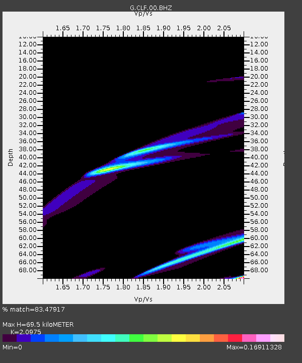
| Estimated Moho Depth: |
69.5 km |
| Estimated Crust Vp/Vs: |
2.10 |
| Assumed Crust Vp: |
6.12 km/s |
| Estimated Crust Vs: |
2.918 km/s |
| Estimated Crust Poisson's Ratio: |
0.35 |
|
| Radial Match: |
83.47917 % |
| Radial Bump: |
329 |
| Transverse Match: |
52.84555 % |
| Transverse Bump: |
400 |
| SOD ConfigId: |
2622 |
| Insert Time: |
2010-02-26 21:53:18.469 +0000 |
| GWidth: |
2.5 |
| Max Bumps: |
400 |
| Tol: |
0.001 |
|
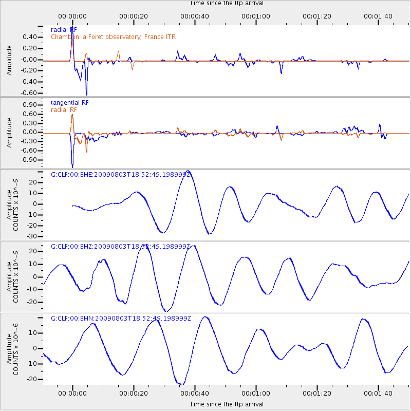
Signal To Noise
| Channel | StoN | STA | LTA |
| G:CLF:00:BHZ:20090803T18:52:49.198999Z | 0.965832 | 7.1055033E-6 | 7.356873E-6 |
| G:CLF:00:BHN:20090803T18:52:49.198999Z | 1.3128626 | 7.5238845E-6 | 5.7309E-6 |
| G:CLF:00:BHE:20090803T18:52:49.198999Z | 3.7061584 | 1.9156472E-5 | 5.168822E-6 |
| Arrivals |
| Ps | 13 SECOND |
| PpPs | 35 SECOND |
| PsPs/PpSs | 47 SECOND |


