You are here: Home > Network List > TA - USArray Transportable Network (new EarthScope stations) Stations List
> Station 137A Heron Place, Grans Saline, TX, USA > Earthquake Result Viewer
137A Heron Place, Grans Saline, TX, USA - Earthquake Result Viewer
| Earthquake location: |
Near East Coast Of Honshu, Japan |
| Earthquake latitude/longitude: |
36.9/141.0 |
| Earthquake time(UTC): |
2011/07/30 (211) 18:53:49 GMT |
| Earthquake Depth: |
30 km |
| Earthquake Magnitude: |
6.4 MB, 6.0 MS, 6.5 MW, 6.4 MW |
| Earthquake Catalog/Contributor: |
WHDF/NEIC |
|
| Network: |
TA USArray Transportable Network (new EarthScope stations) |
| Station: |
137A Heron Place, Grans Saline, TX, USA |
| Lat/Lon: |
32.60 N/95.76 W |
| Elevation: |
141 m |
|
| Distance: |
92.9 deg |
| Az: |
44.953 deg |
| Baz: |
317.888 deg |
| Ray Param: |
0.041361224 |
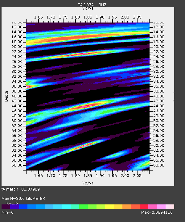
| Estimated Moho Depth: |
36.0 km |
| Estimated Crust Vp/Vs: |
1.60 |
| Assumed Crust Vp: |
6.245 km/s |
| Estimated Crust Vs: |
3.903 km/s |
| Estimated Crust Poisson's Ratio: |
0.18 |
|
| Radial Match: |
81.87909 % |
| Radial Bump: |
400 |
| Transverse Match: |
72.41401 % |
| Transverse Bump: |
359 |
| SOD ConfigId: |
408116 |
| Insert Time: |
2012-01-01 01:17:46.265 +0000 |
| GWidth: |
2.5 |
| Max Bumps: |
400 |
| Tol: |
0.001 |
|

Signal To Noise
| Channel | StoN | STA | LTA |
| TA:137A: :BHZ:20110730T19:06:28.20002Z | 26.011219 | 2.4873625E-6 | 9.562653E-8 |
| TA:137A: :BHN:20110730T19:06:28.20002Z | 2.9758778 | 5.216825E-7 | 1.7530374E-7 |
| TA:137A: :BHE:20110730T19:06:28.20002Z | 1.5375776 | 4.3976968E-7 | 2.8601463E-7 |
| Arrivals |
| Ps | 3.5 SECOND |
| PpPs | 15 SECOND |
| PsPs/PpSs | 18 SECOND |


