You are here: Home > Network List > G - GEOSCOPE Stations List
> Station CLF Chambon la Foret observatory, France > Earthquake Result Viewer
CLF Chambon la Foret observatory, France - Earthquake Result Viewer
| Earthquake location: |
Near S. Coast Of Honshu, Japan |
| Earthquake latitude/longitude: |
33.2/137.9 |
| Earthquake time(UTC): |
2009/08/09 (221) 10:55:55 GMT |
| Earthquake Depth: |
297 km |
| Earthquake Magnitude: |
6.5 MB, 7.1 MW, 7.1 MW |
| Earthquake Catalog/Contributor: |
WHDF/NEIC |
|
| Network: |
G GEOSCOPE |
| Station: |
CLF Chambon la Foret observatory, France |
| Lat/Lon: |
48.03 N/2.26 E |
| Elevation: |
145 m |
|
| Distance: |
90.0 deg |
| Az: |
332.031 deg |
| Baz: |
35.874 deg |
| Ray Param: |
0.04163847 |
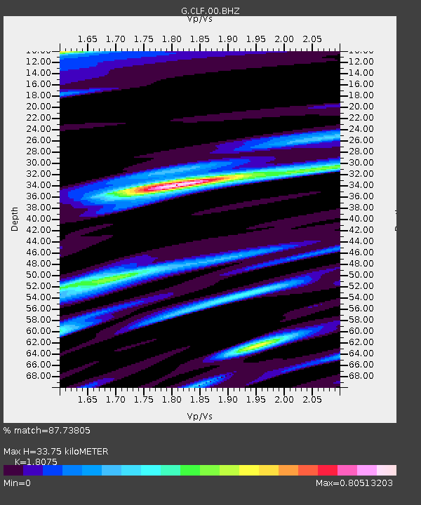
| Estimated Moho Depth: |
33.75 km |
| Estimated Crust Vp/Vs: |
1.81 |
| Assumed Crust Vp: |
6.12 km/s |
| Estimated Crust Vs: |
3.386 km/s |
| Estimated Crust Poisson's Ratio: |
0.28 |
|
| Radial Match: |
87.73805 % |
| Radial Bump: |
400 |
| Transverse Match: |
67.465096 % |
| Transverse Bump: |
400 |
| SOD ConfigId: |
2622 |
| Insert Time: |
2010-02-26 21:53:19.837 +0000 |
| GWidth: |
2.5 |
| Max Bumps: |
400 |
| Tol: |
0.001 |
|
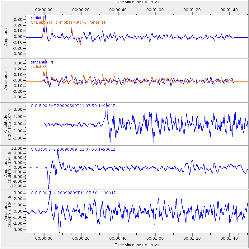
Signal To Noise
| Channel | StoN | STA | LTA |
| G:CLF:00:BHZ:20090809T11:07:50.149001Z | 38.67039 | 4.7748085E-6 | 1.2347454E-7 |
| G:CLF:00:BHN:20090809T11:07:50.149001Z | 8.182298 | 1.354306E-6 | 1.6551658E-7 |
| G:CLF:00:BHE:20090809T11:07:50.149001Z | 8.677045 | 1.070621E-6 | 1.2338543E-7 |
| Arrivals |
| Ps | 4.5 SECOND |
| PpPs | 15 SECOND |
| PsPs/PpSs | 20 SECOND |


