You are here: Home > Network List > G - GEOSCOPE Stations List
> Station CLF Chambon la Foret observatory, France > Earthquake Result Viewer
CLF Chambon la Foret observatory, France - Earthquake Result Viewer
| Earthquake location: |
Southeast Of Honshu, Japan |
| Earthquake latitude/longitude: |
32.8/140.4 |
| Earthquake time(UTC): |
2009/08/12 (224) 22:48:51 GMT |
| Earthquake Depth: |
53 km |
| Earthquake Magnitude: |
6.2 MB, 6.6 MW, 6.6 MW |
| Earthquake Catalog/Contributor: |
WHDF/NEIC |
|
| Network: |
G GEOSCOPE |
| Station: |
CLF Chambon la Foret observatory, France |
| Lat/Lon: |
48.03 N/2.26 E |
| Elevation: |
145 m |
|
| Distance: |
91.2 deg |
| Az: |
333.379 deg |
| Baz: |
34.199 deg |
| Ray Param: |
0.041609913 |
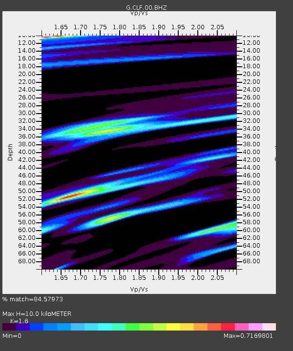
| Estimated Moho Depth: |
10.0 km |
| Estimated Crust Vp/Vs: |
1.60 |
| Assumed Crust Vp: |
6.12 km/s |
| Estimated Crust Vs: |
3.825 km/s |
| Estimated Crust Poisson's Ratio: |
0.18 |
|
| Radial Match: |
84.57973 % |
| Radial Bump: |
400 |
| Transverse Match: |
84.48908 % |
| Transverse Bump: |
400 |
| SOD ConfigId: |
2622 |
| Insert Time: |
2010-02-26 21:53:20.954 +0000 |
| GWidth: |
2.5 |
| Max Bumps: |
400 |
| Tol: |
0.001 |
|
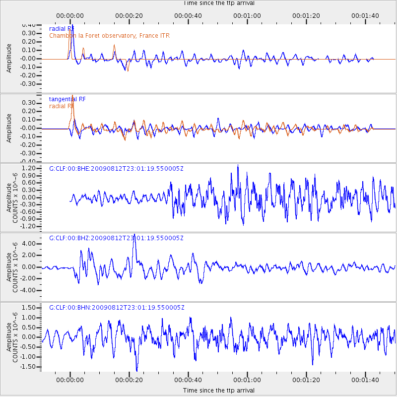
Signal To Noise
| Channel | StoN | STA | LTA |
| G:CLF:00:BHZ:20090812T23:01:19.550005Z | 11.003773 | 1.2930143E-6 | 1.1750645E-7 |
| G:CLF:00:BHN:20090812T23:01:19.550005Z | 2.0823886 | 3.4102914E-7 | 1.6376825E-7 |
| G:CLF:00:BHE:20090812T23:01:19.550005Z | 1.8416609 | 2.4725006E-7 | 1.3425385E-7 |
| Arrivals |
| Ps | 1.0 SECOND |
| PpPs | 4.2 SECOND |
| PsPs/PpSs | 5.2 SECOND |


