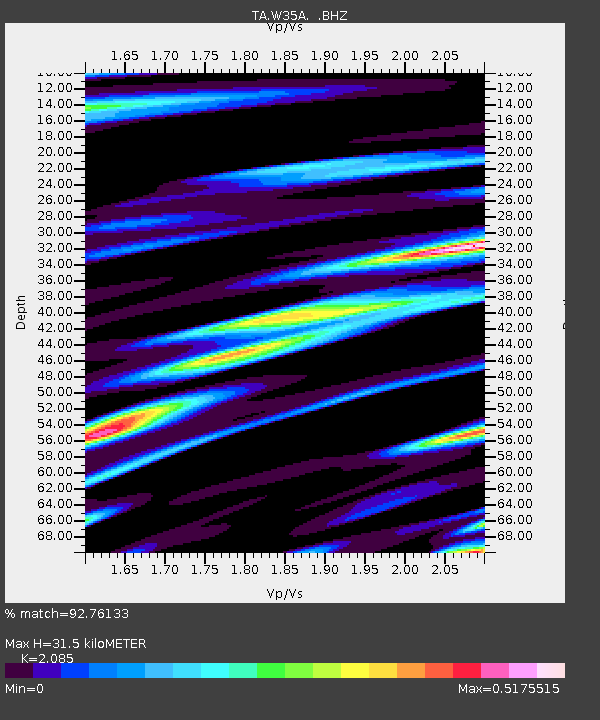
W35A Tecumseh, OK, USA - Earthquake Result Viewer

Earthquake location: Near East Coast Of Honshu, Japan
Earthquake latitude/longitude: 36.9/141.0
Earthquake time(UTC): 2011/07/30 (211) 18:53:49 GMT
Earthquake Depth: 30 km
Earthquake Magnitude: 6.4 MB, 6.0 MS, 6.5 MW, 6.4 MW
Earthquake Catalog/Contributor: WHDF/NEIC
Network: TA USArray Transportable Network (new EarthScope stations)
Station: W35A Tecumseh, OK, USA
Lat/Lon: 35.15 N/96.87 W
Elevation: 322 m
Distance: 90.4 deg
Az: 43.921 deg
Baz: 317.296 deg
Ray Param: 0.04167462
Estimated Moho Depth: 31.5 km
Estimated Crust Vp/Vs: 2.09
Assumed Crust Vp: 6.426 km/s
Estimated Crust Vs: 3.082 km/s
Estimated Crust Poisson's Ratio: 0.35
Radial Match: 92.76133 %
Radial Bump: 342
Transverse Match: 83.27295 %
Transverse Bump: 400
SOD ConfigId: 408116
Insert Time: 2012-01-01 01:18:36.925 +0000
GWidth: 2.5
Max Bumps: 400
Tol: 0.001

Signal To Noise

ChannelStoNSTALTA
TA:W35A: :BHZ:20110730T19:06:16.625007Z59.0019343.9136676E-66.6331175E-8
TA:W35A: :BHN:20110730T19:06:16.625007Z7.58134177.6599315E-71.0103662E-7
TA:W35A: :BHE:20110730T19:06:16.625007Z6.11408856.635038E-71.08520474E-7
Arrivals
Ps5.4 SECOND
PpPs15 SECOND
PsPs/PpSs20 SECOND