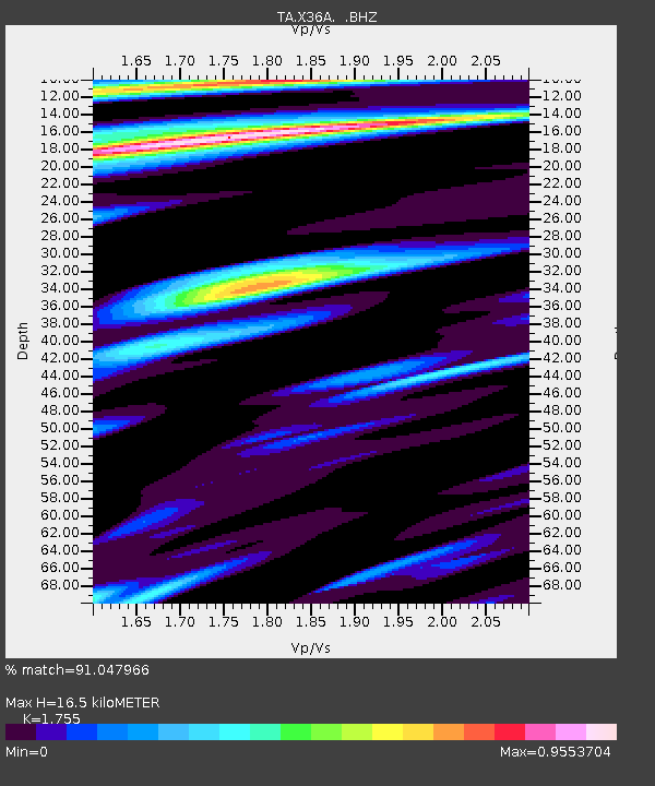
X36A Centrahoma, OK, USA - Earthquake Result Viewer

Earthquake location: Near East Coast Of Honshu, Japan
Earthquake latitude/longitude: 36.9/141.0
Earthquake time(UTC): 2011/07/30 (211) 18:53:49 GMT
Earthquake Depth: 30 km
Earthquake Magnitude: 6.4 MB, 6.0 MS, 6.5 MW, 6.4 MW
Earthquake Catalog/Contributor: WHDF/NEIC
Network: TA USArray Transportable Network (new EarthScope stations)
Station: X36A Centrahoma, OK, USA
Lat/Lon: 34.57 N/96.35 W
Elevation: 211 m
Distance: 91.1 deg
Az: 43.998 deg
Baz: 317.593 deg
Ray Param: 0.04162338
Estimated Moho Depth: 16.5 km
Estimated Crust Vp/Vs: 1.75
Assumed Crust Vp: 6.426 km/s
Estimated Crust Vs: 3.662 km/s
Estimated Crust Poisson's Ratio: 0.26
Radial Match: 91.047966 %
Radial Bump: 400
Transverse Match: 81.48994 %
Transverse Bump: 400
SOD ConfigId: 408116
Insert Time: 2012-01-01 01:18:50.015 +0000
GWidth: 2.5
Max Bumps: 400
Tol: 0.001

Signal To Noise

ChannelStoNSTALTA
TA:X36A: :BHZ:20110730T19:06:19.924995Z24.9335774.0718523E-61.63308E-7
TA:X36A: :BHN:20110730T19:06:19.924995Z4.42869046.5053285E-71.4689056E-7
TA:X36A: :BHE:20110730T19:06:19.924995Z3.8770535.8243796E-71.5022698E-7
Arrivals
Ps2.0 SECOND
PpPs6.9 SECOND
PsPs/PpSs8.9 SECOND