You are here: Home > Network List > TA - USArray Transportable Network (new EarthScope stations) Stations List
> Station Z39A Irene McRaven, Queen City, TX, USA > Earthquake Result Viewer
Z39A Irene McRaven, Queen City, TX, USA - Earthquake Result Viewer
| Earthquake location: |
Near East Coast Of Honshu, Japan |
| Earthquake latitude/longitude: |
36.9/141.0 |
| Earthquake time(UTC): |
2011/07/30 (211) 18:53:49 GMT |
| Earthquake Depth: |
30 km |
| Earthquake Magnitude: |
6.4 MB, 6.0 MS, 6.5 MW, 6.4 MW |
| Earthquake Catalog/Contributor: |
WHDF/NEIC |
|
| Network: |
TA USArray Transportable Network (new EarthScope stations) |
| Station: |
Z39A Irene McRaven, Queen City, TX, USA |
| Lat/Lon: |
33.24 N/94.18 W |
| Elevation: |
112 m |
|
| Distance: |
93.3 deg |
| Az: |
43.535 deg |
| Baz: |
318.815 deg |
| Ray Param: |
0.041282255 |
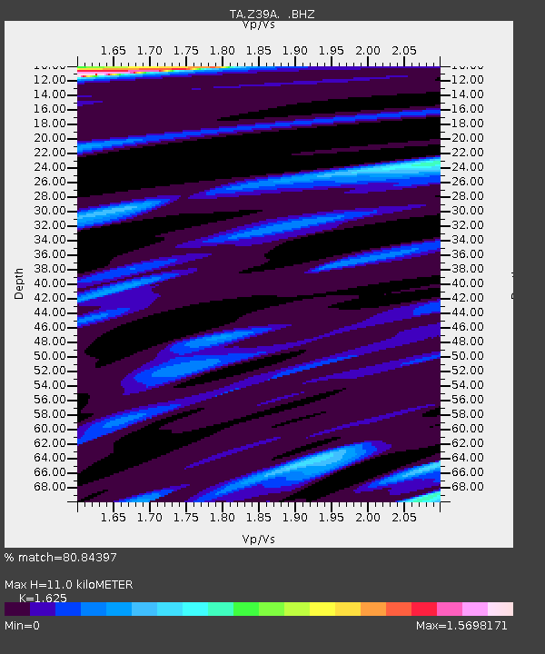
| Estimated Moho Depth: |
11.0 km |
| Estimated Crust Vp/Vs: |
1.62 |
| Assumed Crust Vp: |
6.245 km/s |
| Estimated Crust Vs: |
3.843 km/s |
| Estimated Crust Poisson's Ratio: |
0.20 |
|
| Radial Match: |
80.84397 % |
| Radial Bump: |
400 |
| Transverse Match: |
72.84484 % |
| Transverse Bump: |
400 |
| SOD ConfigId: |
408116 |
| Insert Time: |
2012-01-01 01:19:28.467 +0000 |
| GWidth: |
2.5 |
| Max Bumps: |
400 |
| Tol: |
0.001 |
|

Signal To Noise
| Channel | StoN | STA | LTA |
| TA:Z39A: :BHZ:20110730T19:06:30.024971Z | 19.611736 | 3.328415E-6 | 1.6971546E-7 |
| TA:Z39A: :BHN:20110730T19:06:30.024971Z | 3.3101025 | 7.8640977E-7 | 2.3757867E-7 |
| TA:Z39A: :BHE:20110730T19:06:30.024971Z | 1.8452164 | 5.601748E-7 | 3.0358217E-7 |
| Arrivals |
| Ps | 1.1 SECOND |
| PpPs | 4.5 SECOND |
| PsPs/PpSs | 5.7 SECOND |


