Y38A Idabel, OK, USA - Earthquake Result Viewer
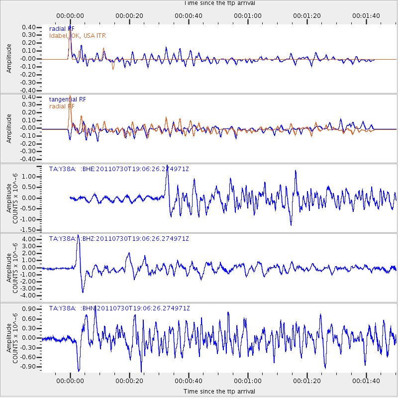
Earthquake location: Near East Coast Of Honshu, Japan
Earthquake latitude/longitude: 36.9/141.0
Earthquake time(UTC): 2011/07/30 (211) 18:53:49 GMT
Earthquake Depth: 30 km
Earthquake Magnitude: 6.4 MB, 6.0 MS, 6.5 MW, 6.4 MW
Earthquake Catalog/Contributor: WHDF/NEIC
Network: TA USArray Transportable Network (new EarthScope stations)
Station: Y38A Idabel, OK, USA
Lat/Lon: 33.93 N/94.73 W
Elevation: 118 m
Distance: 92.5 deg
Az: 43.427 deg
Baz: 318.519 deg
Ray Param: 0.041443657
Estimated Moho Depth: 25.0 km
Estimated Crust Vp/Vs: 1.91
Assumed Crust Vp: 6.245 km/s
Estimated Crust Vs: 3.265 km/s
Estimated Crust Poisson's Ratio: 0.31
Radial Match: 86.44357 %
Radial Bump: 400
Transverse Match: 82.77228 %
Transverse Bump: 400
SOD ConfigId: 408116
Insert Time: 2012-01-01 01:19:36.188 +0000
GWidth: 2.5
Max Bumps: 400
Tol: 0.001

Signal To Noise

ChannelStoNSTALTA
TA:Y38A: :BHZ:20110730T19:06:26.274971Z32.377032.172602E-66.710319E-8
TA:Y38A: :BHN:20110730T19:06:26.274971Z5.19535883.858274E-77.426386E-8
TA:Y38A: :BHE:20110730T19:06:26.274971Z6.10874846.046311E-79.89779E-8
Arrivals
Ps3.7 SECOND
PpPs11 SECOND
PsPs/PpSs15 SECOND