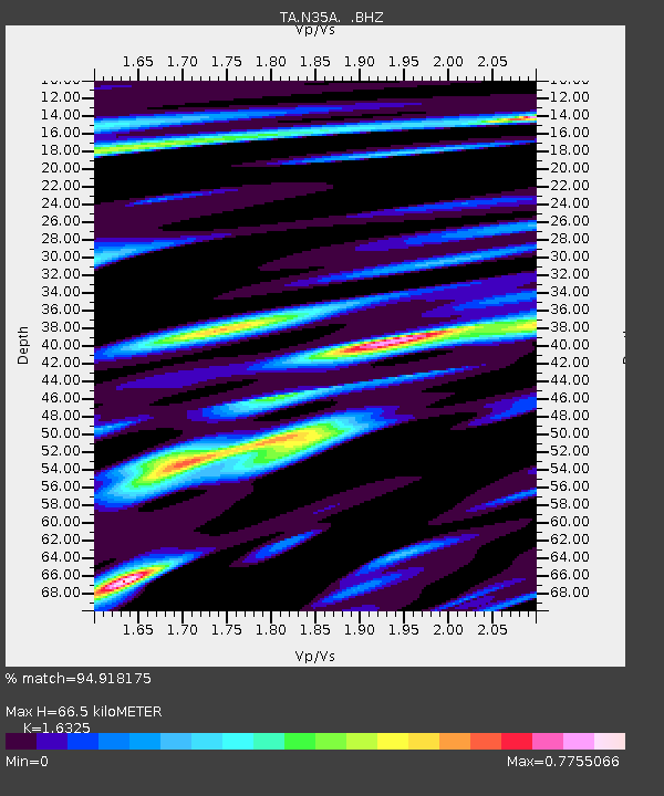
N35A Tabor, IA, USA - Earthquake Result Viewer
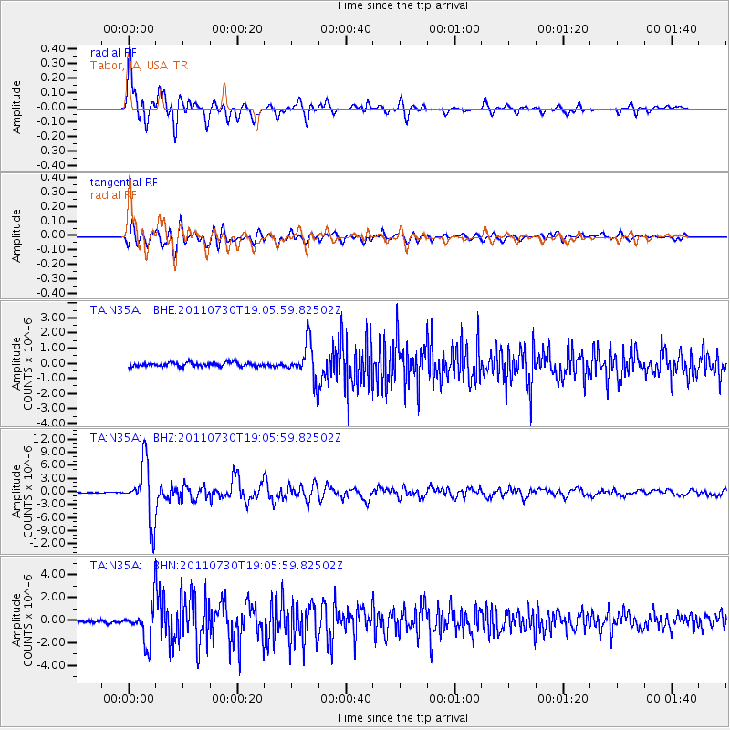
Earthquake location: Near East Coast Of Honshu, Japan
Earthquake latitude/longitude: 36.9/141.0
Earthquake time(UTC): 2011/07/30 (211) 18:53:49 GMT
Earthquake Depth: 30 km
Earthquake Magnitude: 6.4 MB, 6.0 MS, 6.5 MW, 6.4 MW
Earthquake Catalog/Contributor: WHDF/NEIC
Network: TA USArray Transportable Network (new EarthScope stations)
Station: N35A Tabor, IA, USA
Lat/Lon: 40.86 N/95.64 W
Elevation: 353 m
Distance: 86.8 deg
Az: 39.36 deg
Baz: 317.941 deg
Ray Param: 0.04373816
Estimated Moho Depth: 66.5 km
Estimated Crust Vp/Vs: 1.63
Assumed Crust Vp: 6.498 km/s
Estimated Crust Vs: 3.98 km/s
Estimated Crust Poisson's Ratio: 0.20
Radial Match: 94.918175 %
Radial Bump: 400
Transverse Match: 89.23159 %
Transverse Bump: 400
SOD ConfigId: 408116
Insert Time: 2012-01-01 01:20:12.308 +0000
GWidth: 2.5
Max Bumps: 400
Tol: 0.001

Signal To Noise

ChannelStoNSTALTA
TA:N35A: :BHZ:20110730T19:05:59.82502Z83.283096.5347313E-67.846408E-8
TA:N35A: :BHN:20110730T19:05:59.82502Z14.0601191.6118532E-61.1464009E-7
TA:N35A: :BHE:20110730T19:05:59.82502Z9.5430581.2508074E-61.3106985E-7
Arrivals
Ps6.6 SECOND
PpPs26 SECOND
PsPs/PpSs33 SECOND