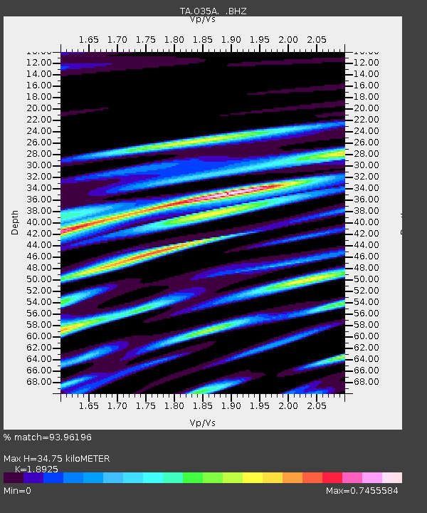
O35A Humboldt, NE, USA - Earthquake Result Viewer
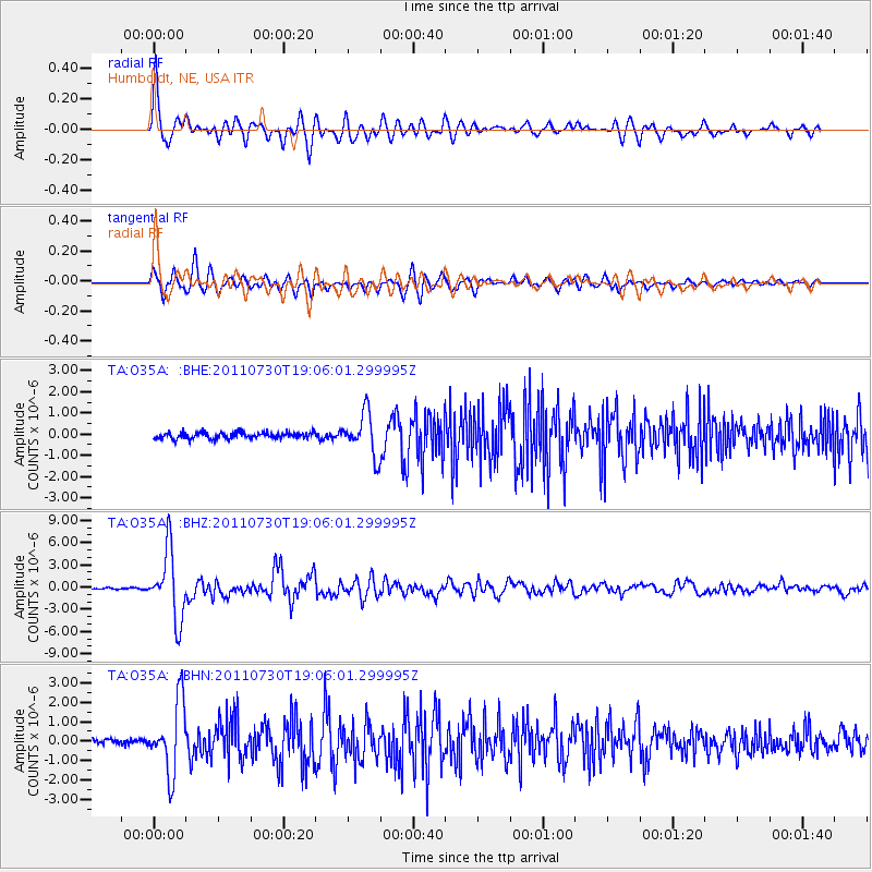
Earthquake location: Near East Coast Of Honshu, Japan
Earthquake latitude/longitude: 36.9/141.0
Earthquake time(UTC): 2011/07/30 (211) 18:53:49 GMT
Earthquake Depth: 30 km
Earthquake Magnitude: 6.4 MB, 6.0 MS, 6.5 MW, 6.4 MW
Earthquake Catalog/Contributor: WHDF/NEIC
Network: TA USArray Transportable Network (new EarthScope stations)
Station: O35A Humboldt, NE, USA
Lat/Lon: 40.27 N/95.91 W
Elevation: 342 m
Distance: 87.1 deg
Az: 39.91 deg
Baz: 317.797 deg
Ray Param: 0.043515544
Estimated Moho Depth: 34.75 km
Estimated Crust Vp/Vs: 1.89
Assumed Crust Vp: 6.498 km/s
Estimated Crust Vs: 3.433 km/s
Estimated Crust Poisson's Ratio: 0.31
Radial Match: 93.96196 %
Radial Bump: 400
Transverse Match: 91.5059 %
Transverse Bump: 400
SOD ConfigId: 408116
Insert Time: 2012-01-01 01:20:18.760 +0000
GWidth: 2.5
Max Bumps: 400
Tol: 0.001

Signal To Noise

ChannelStoNSTALTA
TA:O35A: :BHZ:20110730T19:06:01.299995Z49.9478034.6002638E-69.210142E-8
TA:O35A: :BHN:20110730T19:06:01.299995Z9.5479991.8173537E-61.9033868E-7
TA:O35A: :BHE:20110730T19:06:01.299995Z6.76242359.982645E-71.4761933E-7
Arrivals
Ps4.9 SECOND
PpPs15 SECOND
PsPs/PpSs20 SECOND