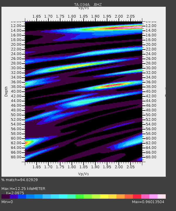
O34A Beatrice, NE, USA - Earthquake Result Viewer
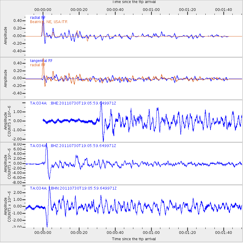
Earthquake location: Near East Coast Of Honshu, Japan
Earthquake latitude/longitude: 36.9/141.0
Earthquake time(UTC): 2011/07/30 (211) 18:53:49 GMT
Earthquake Depth: 30 km
Earthquake Magnitude: 6.4 MB, 6.0 MS, 6.5 MW, 6.4 MW
Earthquake Catalog/Contributor: WHDF/NEIC
Network: TA USArray Transportable Network (new EarthScope stations)
Station: O34A Beatrice, NE, USA
Lat/Lon: 40.18 N/96.69 W
Elevation: 409 m
Distance: 86.8 deg
Az: 40.41 deg
Baz: 317.319 deg
Ray Param: 0.04376712
Estimated Moho Depth: 12.25 km
Estimated Crust Vp/Vs: 2.10
Assumed Crust Vp: 6.498 km/s
Estimated Crust Vs: 3.098 km/s
Estimated Crust Poisson's Ratio: 0.35
Radial Match: 94.82929 %
Radial Bump: 378
Transverse Match: 91.37855 %
Transverse Bump: 400
SOD ConfigId: 408116
Insert Time: 2012-01-01 01:21:57.620 +0000
GWidth: 2.5
Max Bumps: 400
Tol: 0.001

Signal To Noise

ChannelStoNSTALTA
TA:O34A: :BHZ:20110730T19:05:59.649971Z68.9551243.9131673E-65.6749485E-8
TA:O34A: :BHN:20110730T19:05:59.649971Z12.3777181.3981174E-61.1295438E-7
TA:O34A: :BHE:20110730T19:05:59.649971Z9.8638171.0167271E-61.0307643E-7
Arrivals
Ps2.1 SECOND
PpPs5.7 SECOND
PsPs/PpSs7.8 SECOND