You are here: Home > Network List > TA - USArray Transportable Network (new EarthScope stations) Stations List
> Station M33A Taylor Creek Farms, Clarkson, NE, USA > Earthquake Result Viewer
M33A Taylor Creek Farms, Clarkson, NE, USA - Earthquake Result Viewer

| Earthquake location: |
Near East Coast Of Honshu, Japan |
| Earthquake latitude/longitude: |
36.9/141.0 |
| Earthquake time(UTC): |
2011/07/30 (211) 18:53:49 GMT |
| Earthquake Depth: |
30 km |
| Earthquake Magnitude: |
6.4 MB, 6.0 MS, 6.5 MW, 6.4 MW |
| Earthquake Catalog/Contributor: |
WHDF/NEIC |
|
| Network: |
TA USArray Transportable Network (new EarthScope stations) |
| Station: |
M33A Taylor Creek Farms, Clarkson, NE, USA |
| Lat/Lon: |
41.57 N/97.19 W |
| Elevation: |
503 m |
|
| Distance: |
85.5 deg |
| Az: |
39.743 deg |
| Baz: |
316.947 deg |
| Ray Param: |
0.04468155 |
| Estimated Moho Depth: |
13.0 km |
| Estimated Crust Vp/Vs: |
2.10 |
| Assumed Crust Vp: |
6.498 km/s |
| Estimated Crust Vs: |
3.098 km/s |
| Estimated Crust Poisson's Ratio: |
0.35 |
|
| Radial Match: |
93.86383 % |
| Radial Bump: |
400 |
| Transverse Match: |
90.24381 % |
| Transverse Bump: |
400 |
| SOD ConfigId: |
408116 |
| Insert Time: |
2012-01-01 01:22:23.125 +0000 |
| GWidth: |
2.5 |
| Max Bumps: |
400 |
| Tol: |
0.001 |
|
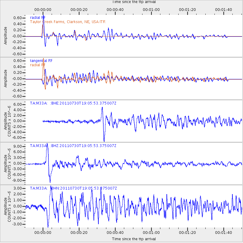
Signal To Noise
| Channel | StoN | STA | LTA |
| TA:M33A: :BHZ:20110730T19:05:53.375007Z | 51.39546 | 5.3763783E-6 | 1.0460804E-7 |
| TA:M33A: :BHN:20110730T19:05:53.375007Z | 9.339142 | 1.7440033E-6 | 1.8674127E-7 |
| TA:M33A: :BHE:20110730T19:05:53.375007Z | 12.677813 | 2.837158E-6 | 2.2378923E-7 |
| Arrivals |
| Ps | 2.2 SECOND |
| PpPs | 6.1 SECOND |
| PsPs/PpSs | 8.3 SECOND |


