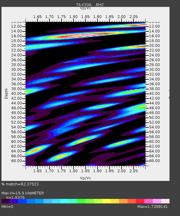
K33A Hardington, NE, USA - Earthquake Result Viewer
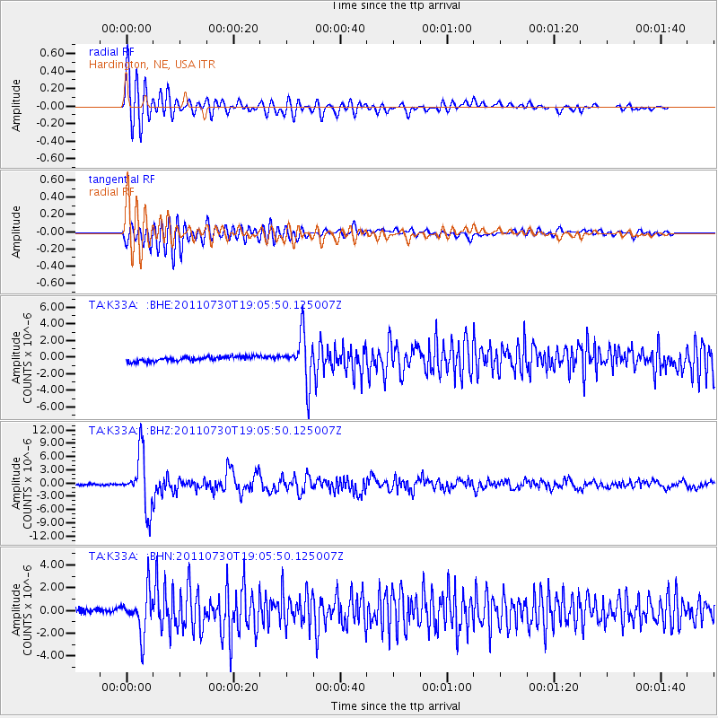
Earthquake location: Near East Coast Of Honshu, Japan
Earthquake latitude/longitude: 36.9/141.0
Earthquake time(UTC): 2011/07/30 (211) 18:53:49 GMT
Earthquake Depth: 30 km
Earthquake Magnitude: 6.4 MB, 6.0 MS, 6.5 MW, 6.4 MW
Earthquake Catalog/Contributor: WHDF/NEIC
Network: TA USArray Transportable Network (new EarthScope stations)
Station: K33A Hardington, NE, USA
Lat/Lon: 42.61 N/97.00 W
Elevation: 507 m
Distance: 84.8 deg
Az: 38.931 deg
Baz: 317.008 deg
Ray Param: 0.04515245
Estimated Moho Depth: 15.5 km
Estimated Crust Vp/Vs: 1.84
Assumed Crust Vp: 6.498 km/s
Estimated Crust Vs: 3.536 km/s
Estimated Crust Poisson's Ratio: 0.29
Radial Match: 92.37523 %
Radial Bump: 400
Transverse Match: 81.535225 %
Transverse Bump: 400
SOD ConfigId: 408116
Insert Time: 2012-01-01 01:23:03.148 +0000
GWidth: 2.5
Max Bumps: 400
Tol: 0.001

Signal To Noise

ChannelStoNSTALTA
TA:K33A: :BHZ:20110730T19:05:50.125007Z35.2047656.1821647E-61.756059E-7
TA:K33A: :BHN:20110730T19:05:50.125007Z9.9097031.8398234E-61.8565876E-7
TA:K33A: :BHE:20110730T19:05:50.125007Z10.076452.8067977E-62.7855026E-7
Arrivals
Ps2.0 SECOND
PpPs6.6 SECOND
PsPs/PpSs8.7 SECOND