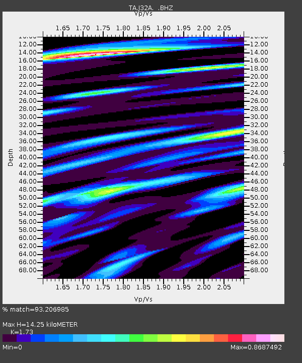
J32A Parkston, SD, USA - Earthquake Result Viewer

Earthquake location: Near East Coast Of Honshu, Japan
Earthquake latitude/longitude: 36.9/141.0
Earthquake time(UTC): 2011/07/30 (211) 18:53:49 GMT
Earthquake Depth: 30 km
Earthquake Magnitude: 6.4 MB, 6.0 MS, 6.5 MW, 6.4 MW
Earthquake Catalog/Contributor: WHDF/NEIC
Network: TA USArray Transportable Network (new EarthScope stations)
Station: J32A Parkston, SD, USA
Lat/Lon: 43.37 N/97.85 W
Elevation: 399 m
Distance: 83.9 deg
Az: 38.857 deg
Baz: 316.426 deg
Ray Param: 0.045848183
Estimated Moho Depth: 14.25 km
Estimated Crust Vp/Vs: 1.73
Assumed Crust Vp: 6.498 km/s
Estimated Crust Vs: 3.756 km/s
Estimated Crust Poisson's Ratio: 0.25
Radial Match: 93.206985 %
Radial Bump: 400
Transverse Match: 83.707794 %
Transverse Bump: 400
SOD ConfigId: 408116
Insert Time: 2012-01-01 01:23:10.415 +0000
GWidth: 2.5
Max Bumps: 400
Tol: 0.001

Signal To Noise

ChannelStoNSTALTA
TA:J32A: :BHZ:20110730T19:05:45.149971Z54.3260275.8351657E-61.0741013E-7
TA:J32A: :BHN:20110730T19:05:45.149971Z12.3545261.6980619E-61.3744452E-7
TA:J32A: :BHE:20110730T19:05:45.149971Z13.7476641.994589E-61.4508566E-7
Arrivals
Ps1.6 SECOND
PpPs5.8 SECOND
PsPs/PpSs7.5 SECOND