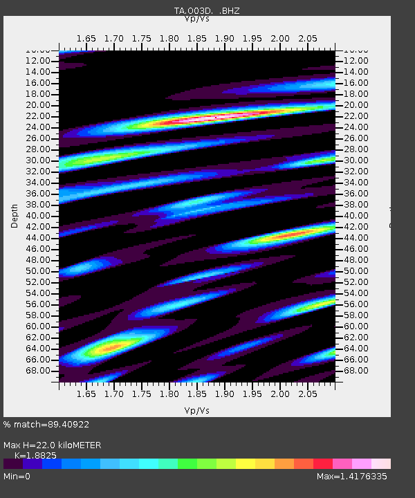
O03D Paynes Creek, CA, USA - Earthquake Result Viewer
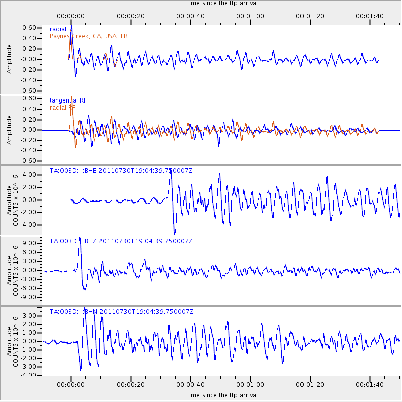
Earthquake location: Near East Coast Of Honshu, Japan
Earthquake latitude/longitude: 36.9/141.0
Earthquake time(UTC): 2011/07/30 (211) 18:53:49 GMT
Earthquake Depth: 30 km
Earthquake Magnitude: 6.4 MB, 6.0 MS, 6.5 MW, 6.4 MW
Earthquake Catalog/Contributor: WHDF/NEIC
Network: TA USArray Transportable Network (new EarthScope stations)
Station: O03D Paynes Creek, CA, USA
Lat/Lon: 40.29 N/121.80 W
Elevation: 968 m
Distance: 72.0 deg
Az: 52.903 deg
Baz: 303.335 deg
Ray Param: 0.053880878
Estimated Moho Depth: 22.0 km
Estimated Crust Vp/Vs: 1.88
Assumed Crust Vp: 6.566 km/s
Estimated Crust Vs: 3.488 km/s
Estimated Crust Poisson's Ratio: 0.30
Radial Match: 89.40922 %
Radial Bump: 400
Transverse Match: 85.267685 %
Transverse Bump: 400
SOD ConfigId: 408116
Insert Time: 2012-01-01 01:24:26.280 +0000
GWidth: 2.5
Max Bumps: 400
Tol: 0.001

Signal To Noise

ChannelStoNSTALTA
TA:O03D: :BHZ:20110730T19:04:39.750007Z50.7223474.593171E-69.055518E-8
TA:O03D: :BHN:20110730T19:04:39.750007Z9.0021671.6558812E-61.839425E-7
TA:O03D: :BHE:20110730T19:04:39.750007Z13.2763142.3192247E-61.7468889E-7
Arrivals
Ps3.1 SECOND
PpPs9.3 SECOND
PsPs/PpSs12 SECOND